- Authorities make an arrest related to deadly January wildfire that leveled LA neighborhood
- AI simulation gives Carolina Hurricanes 20% chance to win 2026 Stanley Cup
- Warf steps down as president of Carolina Hurricanes
- Tornado in North Dakota was the first at EF5 strength in a dozen years
- Eric Tulsky comfortable, confident and going for the Stanley Cup in 2nd year as Hurricanes GM
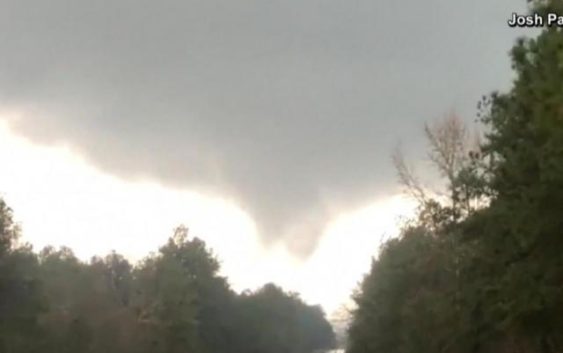
Tornado watch warns south of 'particularly dangerous' storms

A “significant tornado outbreak” was expected to hit parts of the South with dangerous winds and hail Wednesday, the National Weather Service said.
Tornado warnings were in effect across Mississippi and Alabama on Wednesday afternoon, according to Bill Bunting, chief of forecast operations at the Weather Service’s Storm Prediction Center. There were already reports of damaged homes in Wayne County, Mississippi, and wind damage to structures and trees in Sumter County, Alabama, on Wednesday.
A “few dozen thunderstorms” were occurring across the southeastern United States, Bunting said. “We expect them to become stronger and more intense as we move through the next several hours, well into the nighttime hours,” he added.
He said he expected each thunderstorm to produce one tornado. The storms were set to bring winds over 100 mph, as well as hail ranging in size from golf ball to baseball.
The Weather Service issued a “particularly dangerous situation” tornado watch for parts of Louisiana, Arkansas and Mississippi on Wednesday until 7 p.m. Central time, indicating “a potential for multiple strong, long-track tornadoes.”
More than 2.7 million people were at high risk from the storms Wednesday, mostly in Mississippi and Alabama, the Weather Service said, with an additional 5.6 million people at moderate risk.
Gov. Kay Ivey of Alabama issued a state of emergency Tuesday before the storms to “ensure we’re ready to act in any way needed.”
Cities at risk of damage from the storms included Jackson, Mississippi; Birmingham, Alabama; and Tallulah, Louisiana, the Weather Service said. A winter storm hit Jackson in February, leaving more than 70% of the city’s water customers under a notice to boil water for weeks. The notice was lifted last week for well-water customers and on Wednesday for surface-water customers. The rash of storms this week could again threaten the city’s water systems.
“This event is really just getting started,” Bunting said, adding, “It’s going to be a long evening.”
With the storms hitting some areas well after dark, “you can’t see storms approaching very effectively,” Bunting said, advising people to be prepared and take action when warnings are issued and “not wait until they can see the danger.” He said the Weather Service and local meteorologists had been warning residents since this past weekend about the storms.
“For most areas, there will be more than one round of thunderstorms,” he said. “It’s important not to let your guard down after one storm passes.”
The storms will most likely bring “substantial” power outages, downed trees and flooding, he said, adding that structural damage from the “intense, long-track tornadoes” was perhaps the biggest concern.
An “initial round” of tornadoes was expected to continue across Alabama on Wednesday afternoon, the Weather Service said, as a separate cluster was set to develop over northeast Louisiana before spreading east, hitting Mississippi and Alabama — the second round of storms to hit the area — Wednesday evening.
Parts of Georgia, central Tennessee, North Carolina and South Carolina, as well as southern Ohio and Virginia, could be affected by the storms Thursday.
People in areas where tornado warnings are issued should shelter on the lowest floor of their homes and cover themselves with a mattress or pillow, as well as a helmet if one is available, to decrease the risk of injury, Bunting said.