- Couple accused of creating videos of young girls using hidden cameras at The Woodlands Mall, Hurricane Harbor
- Couple accused of creating videos with hidden cameras at The Woodlands Mall, Hurricane Harbor
- The Texanist: Texas Gets More Tornadoes Than Any Other State, but Don’t Freak Out
- U.S. Supreme Court says Texans can sue state for flood damage
- This is how many hurricanes NC State researchers predict this year
Severe weather expected across the Charlotte area Thursday
A storm system will bring the threat of damaging winds, hail and isolated tornadoes to the Charlotte, North Carolina, region Thursday morning and afternoon.
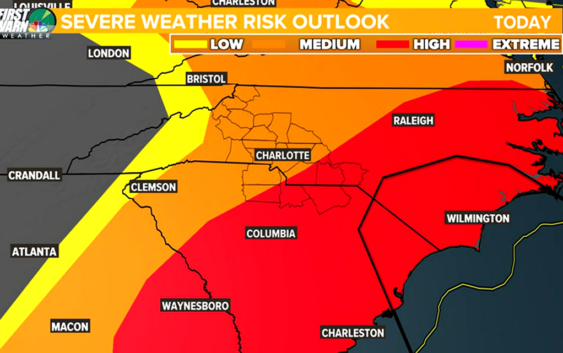
CHARLOTTE, N.C. — Severe weather is forecast to impact the entire Charlotte, North Carolina, area Thursday, including the possibility of strong thunderstorms with high winds, lightning and hail. There’s also the possibility of tornadoes across the Carolinas.
The entire Charlotte metro area is at a “medium” to “high risk” for seeing severe weather. The greatest risk includes areas south and east of Charlotte, including places like Monroe, Wadesboro and Rockingham in North Carolina, as well as Rock Hill, Fort Mill Chesterfield, and Lancaster in South Carolina.
Locations north of Interstate 85 are still considered to be at medium risk of seeing severe weather capable of threatening life and property. Those locations include but are not limited to Gastonia, Hickory, Statesville, Morganton, Salisbury, and the Northern Mountains.
Severe storm outlook
A warm, moist area will move into the Carolinas throughout the morning Thursday. This air will prime the atmosphere with the fuel needed to make supercells, a powerful thunderstorm capable of becoming severe.
As a cold front advances eastward across the Carolinas, the transition between the two air masses is forecast to trig storms. Much like summertime storms, the storms Thursday could trigger both along the front and out ahead of the front. The weather pattern is similar to a summer pattern, whereas discrete, pop-up cells will require everyone to monitor the weather and stay weather aware.
Tornado threat
Along with the high risk comes a 10-15% chance of seeing a tornado in Charlotte and communities south and east. These percentages are very high for the Carolinas.
The probability remains at 10% north and west of Charlotte…into the Foothills and the western North Carolina mountains.
Even the highest elevations, such as Boone and Blowing Rock, still have a 5% chance of seeing a tornado.
By comparison, a typical day has a tornado probability that is a fraction of a single percent.
Damaging wind threat
Damaging winds can occur in any storm — regardless of whether or not that storm is producing a tornado. A Severe Thunderstorm Warning will be issued for any storm that is producing damaging winds in excess of 60 mph.
Of all the forms of severe weather possible Thursday, it is damaging winds that are most likely to be observed on a widespread scale.
Thunderstorm winds are capable of producing damage similar to a tornado. If a Severe Thunderstorm Warning is issued, you should move indoors immediately.
And it’s worth noting: rainfall and lightning are not requirements for Severe Thunderstorm Warnings. Any storm can produce damaging lightning regardless of whether or not it is warned. If you hear thunder, you’re close enough to be struck by lightning and should seek shelter immediately.
Hail Threat
The greatest risk for hail will come during the height of the severe weather window in Charlotte: from 10 a.m. until 4 p.m.
Storms producing damaging hail, defined as hail one inch in size or larger, will prompt the National Weather Service to issue a Severe Thunderstorm Warning.
Hail causes over $1 billion in crop damage every year
Understanding watches vs. warnings
It is likely the National Weather Service will issue a Severe Thunderstorm Watch or a Tornado Watch ahead of the event.
Watches are issued when particular weather conditions, such as thunderstorms or tornadoes, are expected in the hours to follow.
The National Weather Service would issue Severe Thunderstorm Warnings and Tornado Warnings when life-threatening weather is occurring in real-time.
This scenario is already playing out across the South Wednesday, where watches and warnings for tornadoes are issued in states including Arkansas, Mississippi, and Alabama.
If you find yourself within a Tornado Warning, you’ll want to:
- Move to the lowest, and most interior, room inside a sturdy structure. Put as many walls between you and the outside world as possible.
- Stay away from windows and doors.
- Cover yourself in a helmet or blanket.
- Have shoes and pants on before moving to your safe place. If damage occurs during the storm, you will want to be wearing protective clothing when you emerge from your safe place.
How to receive severe weather alerts
The best way to prepare for severe weather Thursday is to be ready now. You can download the WCNC Charlotte Weather app on your phone to get real-time alerts from the weather team as we track the latest in the area.
You should also have a battery-powered NOAA weather radio set to alarm and portable chargers handy in case you lose power during severe weather.
The WCNC Charlotte Weather team will also provide real-time alerts on social media, and we’ll be live on-air and online if conditions get worse. You should also check in with family and friends regularly and let others know of any severe weather headed their way if they’re not aware.