- The Texanist: Texas Gets More Tornadoes Than Any Other State, but Don’t Freak Out
- U.S. Supreme Court says Texans can sue state for flood damage
- This is how many hurricanes NC State researchers predict this year
- NC State researchers predict above-average hurricane season
- Supreme Court rules in favor of property owners suing Texas over flood damage
Tornado Warning issued for Charlotte metro
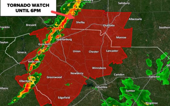
Risk of severe thunderstorms, including the possibility of tornadoes, continues through 6 p.m.
CHARLOTTE, N.C. — A cluster of storms will bring the threat of severe weather to the Charlotte, North Carolina, region Thursday.
The biggest threats associated with the storm system will be damaging winds, hail, and isolated tornadoes.
The National Weather Service (NWS) issued a Tornado Warning for much of the greater Charlotte area viewing area, along with surrounding Carolina counties. In the WCNC Charlotte viewing area, the Tornado Warning is in effect for southern Mecklenburg County, northern York County in South Carolina, and Northern Union County in North Carolina. This Tornado Watch will last until 5:30 p.m. or until the NWS expires it. The watch for Cleveland County was expired around 4:15 p.m. but continued for the aforementioned counties in North Carolina.
Southwest Meckleburg County and York County in South Carolina were also placed under a Severe Thunderstorm Warning until 5 p.m. Affected areas include:
- Uptown Charlotte
- Central Charlotte
- South Charlotte
- Southwest Charlotte
- Pineville
- Tega Cay
- Freedom Park
- The Plaza
- Steele Creek
- The Arboretum
WCNC Charlotte viewer Jake Lackey shared a video of hail coming down in his backyard in Lincolnton, NC, with plenty of it hitting bushes, concrete, and the pool.
WCNC Charlotte Chief Meteorologist Brad Panovich stressed despite a lower than an originally forecast threat, the risk of seeing damaging severe weather still persists.
“We have a 1-4 scale on these outlooks. Yesterday, we had a 3, now it’s a two. It’s still a two, it’s not zero, and that’s important to remember,” Panovich said.
Panovich said it’s likely we could see a tornado watch issued for parts of the viewing area as warm air continues to push into the Carolinas.
Panovich said the Charlotte metro area is now at a “medium risk” for seeing severe weather. Areas included are Uptown Charlotte and the I-77 corridor north of Charlotte. Panovich said he’s growing confident the mountains and foothills of North Carolina likely won’t see any severe weather during Thursday afternoon’s storms. He also expressed concern about movement coming in from the Upstate of South Carolina.
Locations south and east of I-85, including Monroe, Wadesboro and Rockingham in North Carolina, as well as Lancaster and Chester counties in South Carolina, remain in the “high risk” category.
“Across the mountains and foothills, once you get east and southeast of I-85, I really think that’s where we’ve got to watch,” Panovich said.
Severe storm outlook
A warm, moist area moved into the Carolinas Thursday. This warm air will prime the atmosphere with “thunderstorm fuel” needed to make supercells, a powerful thunderstorm capable of becoming severe.
Panovich said that warm air is moving a little slower than initially expected, which is why the mountains and foothills are at lower risk of severe weather. A pocket of cold air lingering over the Carolinas ate up some of that thunderstorm fuel, creating a smaller window of time for strong storms.
Panovich believes the time frame will be anywhere from 1 p.m. until 5 p.m. for the Charlotte area.
“Around 2 or 3 p.m. there’s a little band of storms moving across I-77,” Panovich said. “Anywhere in here, this would be more favorable for strong storms because this is peak heating of the day.”
The weather pattern is similar to a summer pattern, whereas discrete, pop-up cells will require everyone to monitor the weather and stay weather aware.
Tornado threat
Along with the high risk comes a 5-10% chance of seeing a tornado in Charlotte and communities south and east. These percentages are very high for the Carolinas.
The probability remains at 5% north and west of Charlotte, with a lower probability in the mountains and foothills.
Even the highest elevations, such as Boone and Blowing Rock, still have a 5% chance of seeing a tornado.
By comparison, a typical day has a tornado probability that is a fraction of a single percent.
Damaging wind threat
Damaging winds can occur in any storm — regardless of whether or not that storm is producing a tornado. A Severe Thunderstorm Warning will be issued for any storm that is producing damaging winds in excess of 60 mph.
Of all the forms of severe weather possible Thursday, it is damaging winds that are most likely to be observed on a widespread scale.
Thunderstorm winds are capable of producing damage similar to a tornado. If a Severe Thunderstorm Warning is issued, you should move indoors immediately.
And it’s worth noting: rainfall and lightning are not requirements for Severe Thunderstorm Warnings. Any storm can produce damaging lightning regardless of whether or not it is warned. If you hear thunder, you’re close enough to be struck by lightning and should seek shelter immediately.
Hail Threat
The greatest risk for hail will come during the height of the severe weather window in Charlotte: from 12 p.m. until 4 p.m.
Storms producing damaging hail, defined as hail one inch in size or larger, will prompt the National Weather Service to issue a Severe Thunderstorm Warning.
Hail causes over $1 billion in crop damage every year
Understanding watches vs. warnings
It is likely the National Weather Service will issue a Severe Thunderstorm Watch or a Tornado Watch ahead of the event.
Watches are issued when particular weather conditions, such as thunderstorms or tornadoes, are expected in the hours to follow.
The National Weather Service would issue Severe Thunderstorm Warnings and Tornado Warnings when life-threatening weather is occurring in real-time.
This scenario is already playing out across the South Wednesday, where watches and warnings for tornadoes are issued in states including Arkansas, Mississippi, and Alabama.
If you find yourself within a Tornado Warning, you’ll want to:
- Move to the lowest, and most interior, room inside a sturdy structure. Put as many walls between you and the outside world as possible.
- If you live in a high-rise apartment building, get to a lower level or interior stairwell, as far away from windows as possible.
- Stay away from windows and doors.
- Cover yourself in a helmet or blanket.
- Have shoes and pants on before moving to your safe place. If damage occurs during the storm, you will want to be wearing protective clothing when you emerge from your safe place.
Here’s what to do once the Tornado Warning is cleared out:
- Emerge from your safe place carefully
- Make sure you’ve got shoes on so you can leave without hurting your feet on possible fallen debris
- If there’s damage to your property, go ahead and take photos to help file future insurance claims
How to receive severe weather alerts
The best way to prepare for severe weather Thursday is to be ready now. You can download the WCNC Charlotte Weather app on your phone to get real-time alerts from the weather team as we track the latest in the area.
You should also have a battery-powered NOAA weather radio set to alarm and portable chargers handy in case you lose power during severe weather.
The WCNC Charlotte Weather team will also provide real-time alerts on social media, and we’ll be live on-air and online if conditions get worse. You should also check in with family and friends regularly and let others know of any severe weather headed their way if they’re not aware.