- Couple accused of creating videos of young girls using hidden cameras at The Woodlands Mall, Hurricane Harbor
- Couple accused of creating videos with hidden cameras at The Woodlands Mall, Hurricane Harbor
- The Texanist: Texas Gets More Tornadoes Than Any Other State, but Don’t Freak Out
- U.S. Supreme Court says Texans can sue state for flood damage
- This is how many hurricanes NC State researchers predict this year
Tornado confirmed in High Point on Thursday
National Weather Service crews are surveying damage in High Point and Burlington on Friday.
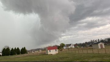
BURLINGTON, N.C. — The National Weather Service confirmed an EF-0 tornado touched down in High Point on Thursday as severe weather rolled through the area.
NWS said its preliminary investigation shows wind speeds got up to 85 mph and the tornado was on the ground for one mile. The circulation was on the ground for about five minutes.
NWS is heading to Burlington next to survey possible tornado damage there.
WFMY News 2 received a photo of what looks like a funnel cloud from viewer Tim Hensley. A number of people on social media shared the same photo of what looks like a funnel cloud in the Burlington area as it quickly became viral. The photo was captured during the tornado-warned storm in the area on Thursday.
Burlington Fire Department estimates around $1 million in damage, mostly to the western portion of Burlington. Significant damage was reported in several areas, including Woodland Heights Apartments off Springwood Church Road, a construction site on Oliver Park Drive, townhomes on Ethans Way near Springwood Park, Limerick Drive and Amherst Drive. Fire officials said no one was hurt.
PHOTOS | Lots of storm damage as Triad gets hit hard by possible tornado
