- Couple accused of creating videos of young girls using hidden cameras at The Woodlands Mall, Hurricane Harbor
- Couple accused of creating videos with hidden cameras at The Woodlands Mall, Hurricane Harbor
- The Texanist: Texas Gets More Tornadoes Than Any Other State, but Don’t Freak Out
- U.S. Supreme Court says Texans can sue state for flood damage
- This is how many hurricanes NC State researchers predict this year
Thursday severe weather drops hail the size of golf balls
A line of severe thunderstorms moving eastward across the Carolinas is producing damage and severe weather.
CHARLOTTE, N.C. — The threat for storms and severe weather will continue for the Charlotte region early Friday morning after a stormy Thursday evening and overnight.
First Warn forecaster Larry Sprinkle said the biggest threat from these storms will be lightning and damaging winds. Gusts up to 50 mph are possible in some areas along I-77 south of Charlotte.
Another line of storms will track just south of the Greenville, South Carolina, area Friday morning.
“About 7 a.m., we’re tracking more heavy rain around Chester County,” Sprinkle said. “There will also be heavier rain from Statesville, North Carolina to around Greensboro.”
Those fast-moving storms will push east at about 50 mph. Some areas could be prone to flash flooding due to heavy rain. A Flood Advisory is in effect for Cabarrus County, North Carolina until 9:45 a.m.
Sprinkle said most of the rain and storms should be out of the Charlotte metro area by around 11 a.m. Friday. This will give way to unseasonably warm temperatures approaching 80 degrees in some areas.
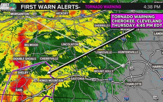
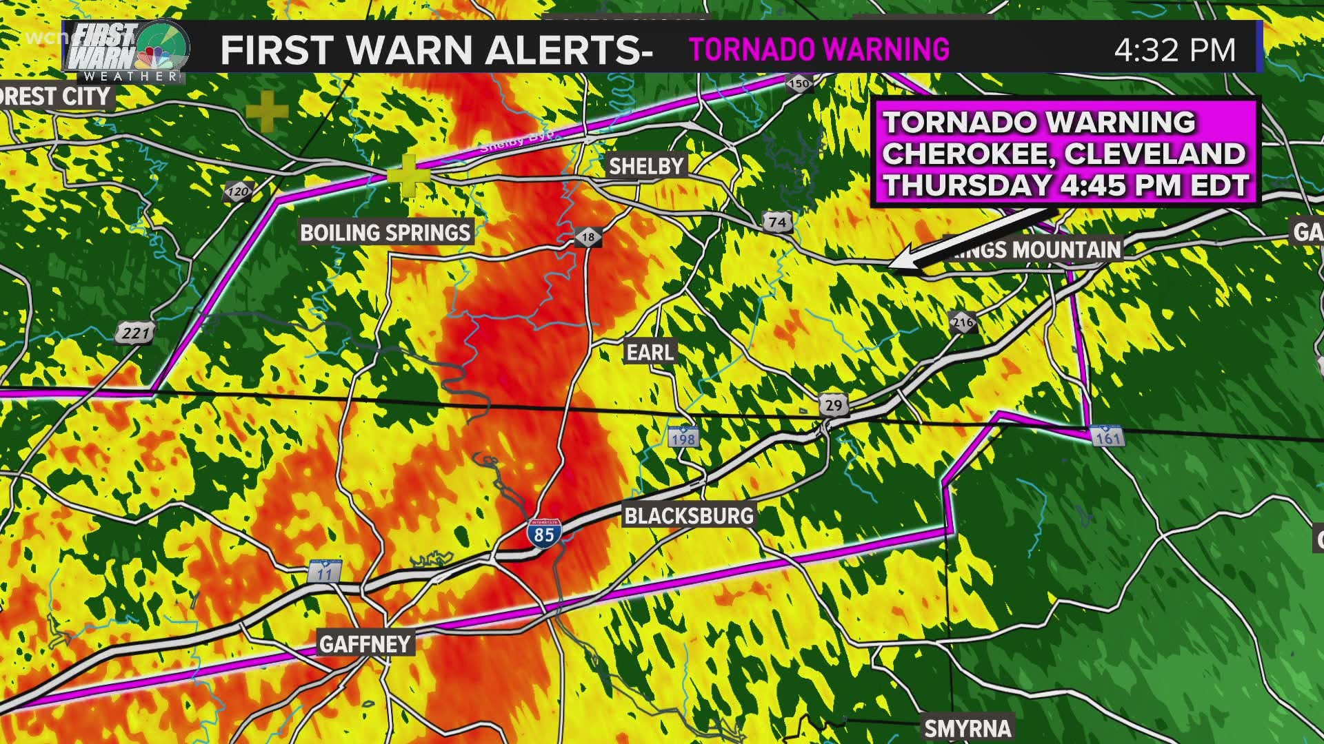
Late Thursday afternoon, a first line of storms moved through the Carolinas prompting the National Weather Service to issue several warnings for potential tornadoes and damaging severe thunderstorms.
The line of storms that moved through during the afternoon hours Thursday was a QLSC, or quasi-linear convective system. While the entire line of storms was not considered severe, the setup allowed for potential-tornadic rotation to spin-up quickly.
QLCS is the meteorological term for what is more commonly known as a squall line. On radar, the system would be recognized as a line of thunderstorms moving more-or-less at the same speed and same direction.
The following video, recorded at 4:40 p.m. during Thursday’s severe weather coverage, explains the severe weather threat from a QLCS line of thunderstorms.
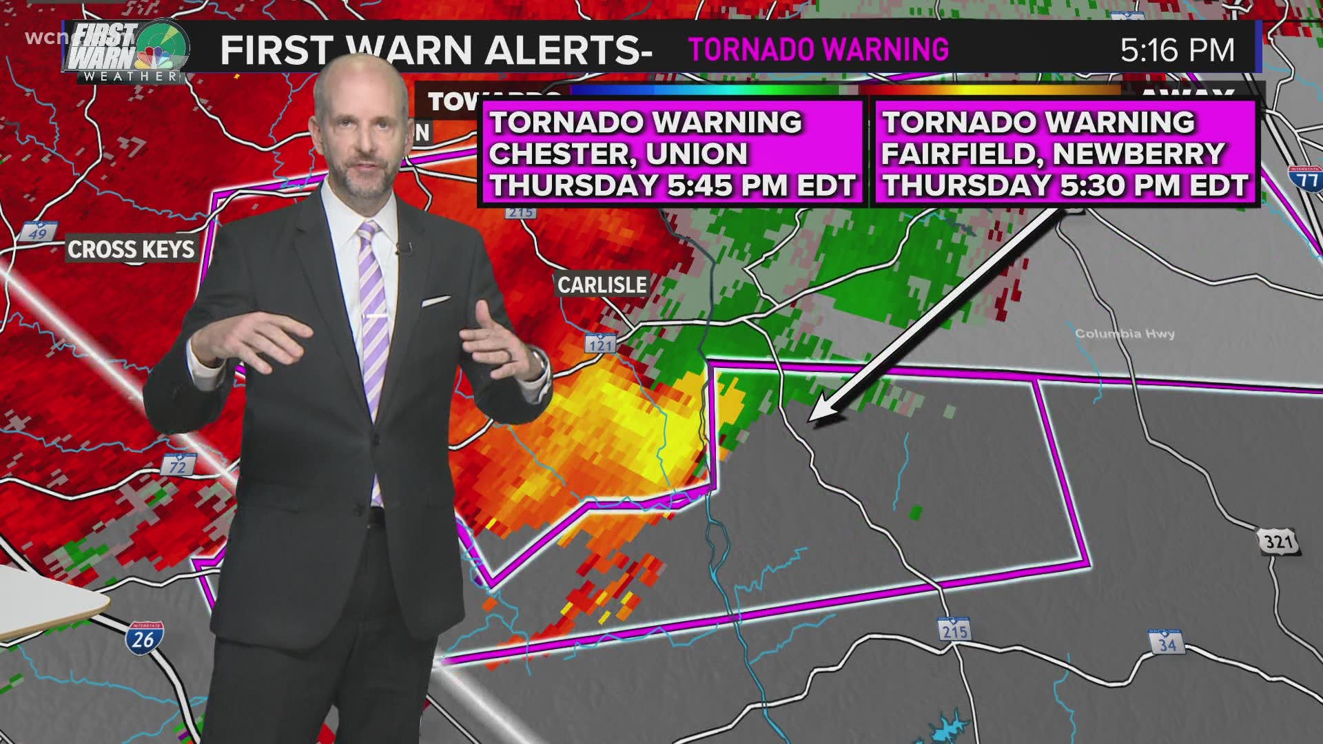
One such quick spin-up came around 6 p.m. as the this first line was moving out of Mecklenburg County. The National Weather Service quickly issued a tornado warning for portions of Union (North Carolina), Stanly, and Cabarrus counties. Despite the radar-indicted rotation, there were no immediate reports of damage in the area.
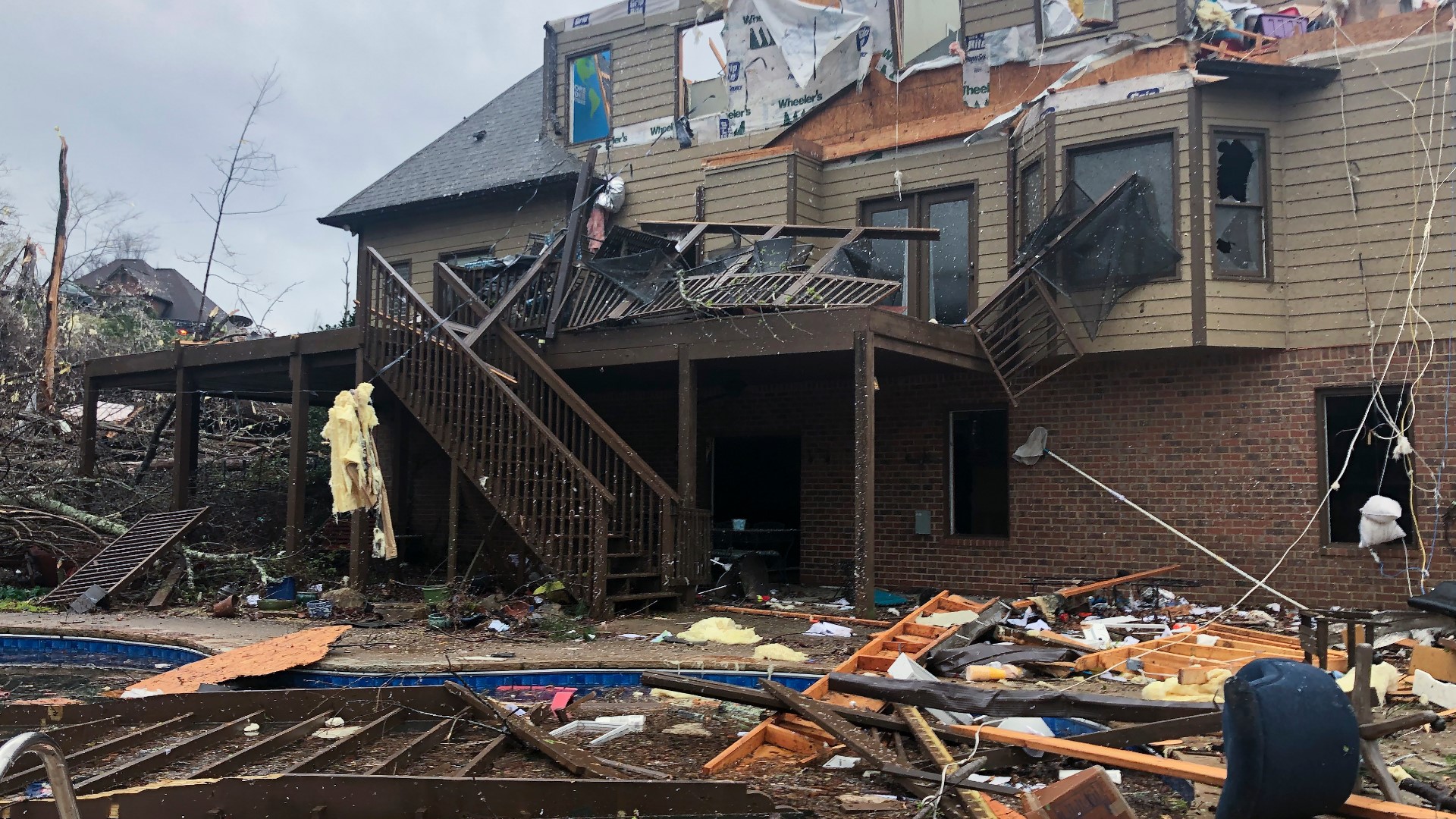
Damage was reported in portions of South Carolina Thursday as a supercell thunderstorm, with the potential for a tornado, moved eastward.
Earlier Thursday, a string of continous tornado warnings had been issued for counties including Chester, Laurens, Union (South Carolina), and Fairfield in South Carolina.
As that severe thunderstorm capable of producing a tornado moved eastward earlier Thursday, it caused damage across several counties:
- Numerous trees down along Green Road south miles south of Irwin in Lancaster County. There were also reports of dime size hail along Hoke Road.
- Trees down in the Rich Hill Community four miles east southeast of Elgin in Lancaster County.
- Trees fell near Hickory Taven in Laurens County, South Carolina.
- More trees were toppled along Highway 72 in the Whitmire area of Newberry County, South Carolina.
- In Union County, South Carolina, one-inch size hail was reported. Numerous trees and powerlines were also down.
- In Fairfield County, South Carolina, one-inch size hail also fell along Old Douglas Road. Trees were also down along Ashford Road near Winnsboro.
- More damage reports were expected to be reported later Thursday.
In Great Falls, South Carolina, hail littered the ground doing its best imitation of snowfall accumulation.
The following video, recorded around 5 p.m. Thursday during severe weather coverage, explains the threat from hail.
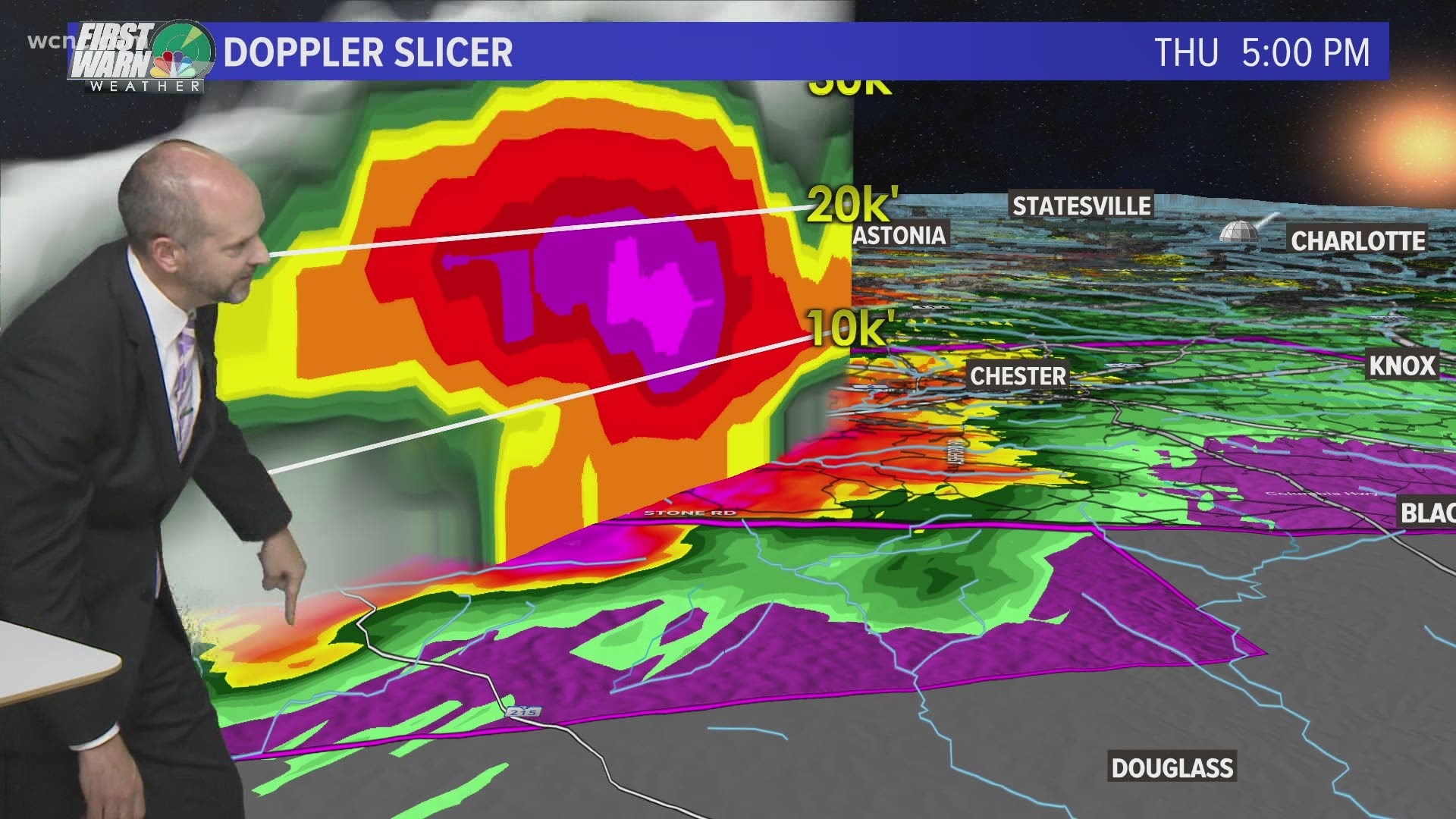
A meteorologist from the National Weather Service would likely have to visit communities impacted and investigate storm damage before they could definitely conclude whether there was a tornado on the ground Thursday.
In events where cameras or human observers cannot see a physical tornado on the ground, the National Weather Service will use radar to infer what is happening in the atmosphere. When rotation is detected inside a thunderstorm, a tornado warning may be issued to warn residents.
This video recorded during severe weather coverage Thursday explains how weather radar works.
If you ever find yourself inside a tornado warning, you should:
- Head into a sturdy structure. Find a location inside the structure that is on the lowest possible level of the structure and the most interior location. You want to put as many walls between you and the outside as possible.
- Stay away from windows.
- If time allows, make sure you’re wearing the following as you head into shelter: Shoes, helmet, pants, and any other protective gear.
- A way to watch or listen to severe weather coverage to know the latest weather threat
The possible-tornadic rotations seen Thursday in the Carolinas are caused by rotation inside these strong-to-severe thunderstorms.
The following video, recorded at 5:15 p.m. during Thursday’s severe weather coverage, explains how rotation is detected on radar inside severe thunderstorms capable of producing tornadoes:
While some scattered strong-to-severe storms are possible in the Carolinas, the nation’s biggest and most extreme risk is again over Mississippi, Alabama, Georgia, and Tennessee — just a week after the Mid-South region also faced the same risk. As of late Thursday, at least five deaths were blamed on the storms.
“I would definitely be a little more weather-aware than normal,” Panovich said referring to the early morning hours Friday. “But on a scale of 1 to 5, we’re probably closer to a 1 for tornadoes, as opposed to like a 3 last week.”
Panovich recommends everyone have two ways to receive severe weather alerts, including the WCNC Charlotte app, which will send alerts to users based on their location.