- Couple accused of creating videos of young girls using hidden cameras at The Woodlands Mall, Hurricane Harbor
- Couple accused of creating videos with hidden cameras at The Woodlands Mall, Hurricane Harbor
- The Texanist: Texas Gets More Tornadoes Than Any Other State, but Don’t Freak Out
- U.S. Supreme Court says Texans can sue state for flood damage
- This is how many hurricanes NC State researchers predict this year
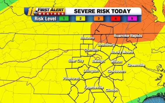
Most of North Carolina under Level 2 severe weather risk on Sunday with wind, hail and isolated tornado possible
The threat for severe weather in central North Carolina continues into Sunday after a strong and quick-moving storm triggered multiple Tornado Warnings in eight counties on Saturday.
For most of Sunday, North Carolina will be placed under a Level 2 out of 5 risk of severe weather, with some counties near the eastern North Carolina-Virginia borderline reaching up to a Level 3.
Timing for the storms is still fluid due to the current weather models. Clouds should be rolling in by early afternoon or even midday.
Another round of severe weather arrives tomorrow. Main threat is damaging winds but large hail & an isolated tornado or two are also possible. There will be a few showers/storms in the morning, but severe storms will be here from 2-7pm. Check with @StewartABC11 Sun AM for updates pic.twitter.com/Ks2ZkAdUZm
— Robert Johnson (@RobJohnsonABC11) March 28, 2021
The main threats for North Carolina will be damaging straight-line winds and hail.
What are straight-line winds and how do they form
Be sure to stay weather aware this weekend by checking in on ABC11.
From around 4:40 p.m. to 7:30 p.m. on Saturday, tornado warnings were in effect for many central North Carolina counties including: Wake, Johnston, Wilson, Wayne, Nash, Lee, Harnett and Moore counties. If you weren’t in a county affected by the Tornado Warnings, you were at least under a Severe Thunderstorm Warning until 8 p.m.
The storm leaving behind downed trees, golf ball-sized hail and nearly 800 people without power in central North Carolina as of 10:30 p.m., according to Duke Energy.
If you can tough out the severe weather of the weekend, Meteorologist Robert Johnson said you can expect sunshine to kick off your week until Wednesday.
Severe weather brings major flash flooding, tornadoes South as threat moves east
Copyright © 2021 WTVD-TV. All Rights Reserved.