Tornado warning in Person County as storms pop up along NC-VA line
Raleigh, N.C. — The National Weather Service issued a tornado warning through 6:30 for northeastern Person County.
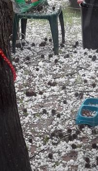
A storm with hail up to the size of a half dollar was located near Milton and Turbeville, moving southeast at 30 mph.
According to WRAL meteorologist Kat Campbell, the entire viewing area is under a Level 1 risk for severe weather, and areas from the Triangle northward, including Durham and Roxboro, are under a stronger Level 2 risk.
Strong hail was reported through the 5 o’clock hour in Angier and across Harnett County.
Almost 400 strikes of lightning were recorded within 15 minutes, according to Campbell.
A severe thunderstorm watch has been issued for some counties northeast of the Triangle, including Edgecombe, Franklin, Granville, Halifax, Nash, Person, Vance, and Warren, through midnight.
According to meteorologist Mike Maze, strong winds and hail will be possible, and there is a small chance for isolated tornadoes. The thunderstorms will continue into the evening.
“The main threats are damaging wind gusts, large hail and perhaps an isolated tornado,” Maze said. “Even though Raleigh is not in the watch and neither are our southern counties, we still have the threat for severe weather for the entire viewing area roughly through midnight. After midnight, there will be showers that will gradually die down.”

Before the severe weather, much of Friday was sunny and quiet. Depending on where you are, storms could be more isolated, and not everyone will see storms.

Saturday we have another threat for severe weather, according to Maze.
“Right now it’s a Level 1 threat but may be upgraded to Level 2 at some point,” he said. “The threats are the same and the main focus of storms may be more in the evening and overnight.”

There is a Level 1 risk in place Sunday along and east of the Interstate 95 corridor, but that could change throughout the weekend.
“Sunday, if there is a severe threat it would be focused in the eastern counties and it should remain a Level 1 threat,” Maze said.
“No day is going to be a washout this weekend and not everybody is going to see rain,” Campbell added. “These are more along the lines for hit-or-miss summer-time thunderstorms.”
Looking ahead to next week, it will be hot and mostly dry, although there will be a chance for a shower on Wednesday.

According to Campbell, although pollen counts typically peak for about three weeks, this week was probably the worst of it.
Campbell said that pine pollen is the yellow pollen that gets all over everything, but it may not be what’s making your eyes water.
“Some of the pollens that cause the biggest issues are the ones that you really can’t see,” Campbell said.