- Couple accused of creating videos of young girls using hidden cameras at The Woodlands Mall, Hurricane Harbor
- Couple accused of creating videos with hidden cameras at The Woodlands Mall, Hurricane Harbor
- The Texanist: Texas Gets More Tornadoes Than Any Other State, but Don’t Freak Out
- U.S. Supreme Court says Texans can sue state for flood damage
- This is how many hurricanes NC State researchers predict this year
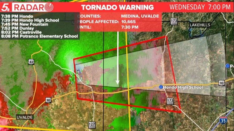
Tornado Warning in effect for Bexar, Medina, Uvalde counties; Tornado Watch in effect for parts of South Texas until 11 p.m.
The primary threats for the region Wednesday night will be large hail, damaging wind gusts of up to 70 mph and isolated tornadoes.
SAN ANTONIO —
Current Watches and Warnings
TORNADO WARNING: Portions of West Central Bexar County are under a Tornado Warning for 8 p.m.
Medina and Uvalde Counties are under a Tornado Warning until 8:15 p.m. The storm is moving east moving at a speed of 40 mph.
A confirmed tornado touched down 11 miles of Hondo. Damage on the road and power flashes were observed, according to an official spotter report from the National Weather Service.
In Medina County, a large tornado was spotted moving east over Highway 90 west of Hondo. Debris was spotted in the air The National Weather Service says those in Hondo need to take shelter. Residents between Castroville and Devine need to make preparations to stay safe.
Western Bexar County needs to watch this tornadic storm closely.
Tornado Watch: Bandera, Blanco, Bexar, Dimmit, Edwards, Frio, Gillespie, Kendall, Kerr, Kimble, Kinney, Llano, Mason, Maverick, McCulloch, Medina, Menard, Real, San Saba, Schleicher, Sutton, Uvalde, Val Verde and Zavala counties until 11 p.m.
Severe Thunderstorm Warning: Portions of Bandera, Medina, Real and Uvalde counties until 8:15 p.m.
Latest Updates
Parts of south Texas, including San Antonio, remain under a Tornado Watch until 11 p.m. Wednesday, amid an increasing threat for severe thunderstorms late-afternoon and evening. A Level 3 (out of 5) enhanced risk includes the Hill Country, Edwards Plateau and the Rio Grande region.
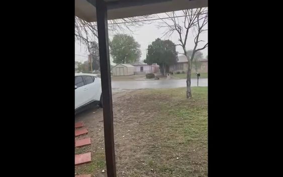
Afternoon storms have already brought hail raining down in south Texas communities, some of it large apple-sized. Hail will remain a weather threat throughout the region as storms continue to push through.
The biggest difference in Wednesday’s severe weather threat is the “cap.”
What is the “cap?” It’s basically relatively warmer air overhead.
The cap was strong on Tuesday and this acts as a “lid,” suppressing the development of thunderstorms.
Time-lapse of tonight’s storms
Here’s why we are under a Tornado Watch:
Now that the cap has eroded, thunderstorms have developed quickly over parts of the Hill Country and the Rio Grande.
Large hail will remain the primary threat here, but an isolated tornado in the region can’t be ruled out from sunset Wednesday through midnight.
After a few hours, additional noisy thunderstorms will try to develop. All severe weather hazards are still possible.
Severe thunderstorms will try to move east toward I-35 tonight.
Storms are forecast to weaken as they move east.
Here’s what the SPC categories mean:
Stay tuned for severe weather forecast updates on KENS 5 TV and KENS5.com.
Rain will begin to taper off Thursday and it will feel noticeably cooler late week with afternoon temperatures in the mid-70s to low-80s.
This is a developing weather event. Refresh the page for the latest updates.
SEVERE WEATHER 101
When severe weather threatens the area, it is important to know what risks a storm can bring and what you should do to stay safe.
One of the most important things to know is where you are located on a map, so when a watch or warning is put into place, you can identify if you are at risk. When the National Weather Service puts out warnings, they are county-based and sometimes include cities as well. It is important to know where you live in the county and that you can identify it on a map.
It is also important to know the difference between a watch and a warning. A watch means that conditions are favorable for something to happen, but a warning means that something has developed and it is important to take action.
So, what would cause a thunderstorm to be qualified as a “severe” thunderstorm?
Hail that is one inch large is also considered to be about the size of a quarter.
Another ingredient that would lead to a storm becoming severe is if winds are 58 mph or greater.
Winds at this strength could cause damage to roofs and could even cause trees to be knocked down.
Finally, if a tornado is present inside a thunderstorm it would qualify the storm as becoming severe.
In this instance, a tornado warning would be issued.
A tornado watch can be issued for an area if strong storms are expected, and if the storms bring the risk for tornadoes, but not all storms include the threat for tornadoes. The ingredients in the atmosphere for a tornado to form are not always there when storms are present.
If the area you are in is ever under a tornado warning, it is important to know where you should go inside your home.
Head to the lowest, interior room of your home. The basement would be best, but if you don’t have one, head to the first floor of the home and get away from exterior walls, or walls that lead to the outside of the home.
It is also important to stay away from glass. The more walls you can put between you and the outside, the better.
While lightning can be frequent in storms and very dangerous, it does not lead to a storm being qualified as severe.
Remember, when thunder roars, go indoors.
Storms can also lead to flooding. Flooding may not cause a storm to be labeled as being severe, but it is the deadliest kind of weather.
South Texas is known to have major flood events every few years, so it is important to use caution and to always stay out of floodwaters. Remember, turn around, don’t drown.
Entering flood water is very dangerous as you can be swept off of your feet and you don’t know what could be in the water that could hurt you.
The best thing you can do to be ready for severe weather is know what you will do in the event it strikes where you live.
Make sure your family has a severe weather action plan.
Have a place everyone goes inside your home and keep supplies there, such as food, medication, batteries, and flashlights.
Weather Minds Classroom: Take a class in Severe Weather 101
Follow the KENS 5 Weather Team
Don’t forget you can download the KENS 5 app for the latest news and weather information each day while you are on the go.