- List of hurricane names 2024
- Homeowners insurance doesn't cover floods: How to protect your home in North Carolina
- Before and after: See Dubai flooding from space
- No evidence of a tornado in Rock Hill, investigation determines
- Marking 15 years since 19,000 acre wildfire destroyed dozens of homes in Horry County
TIMELINE: Flash Flood Watch continues — here's when you can expect the rain to go away
The KHOU11 Weather team is closely monitoring heavy rainfall that is expected to continue Friday, Saturday and early Sunday.
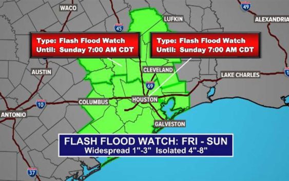
HOUSTON — The National Weather Service has issued a Flash Flood Watch for southeast Texas lasting until 7 a.m. Sunday.
Most of this morning’s high water locations have so far been reported on surface roads (not major highways) areas west, northwest and north of the City of Houston.
FLOODED ROADS: View list of impacted areas and incidents
WEATHER ALERTS: Get the KHOU11 mobile app and turn on weather notifications
WEATHER RADAR: Track storms, rain across Southeast Texas
The areas under a Flash Flood Watch until Sunday morning include the following counties/areas covering a portion of Southeast Texas: Austin, Bolivar Peninsula, Brazoria Islands, Chambers, Coastal Brazoria, Coastal Galveston, Coastal Harris, Coastal Matagorda, Colorado, Fort Bend, Galveston Island, Inland Brazoria, Inland Galveston, Inland Harris, Inland Matagorda, Matagorda Islands, Southern Liberty, Waller and Wharton.
The earlier Flash Flood Warning for the Willis, Montgomery and Prairie View areas has now expired.
Houston weather radar
Timeline: When to expect the heaviest rain, storms in Houston
FRIDAY AM: Expect heavy rain now through 11 a.m. Thunder and rain started entering the downtown area just before 4 a.m. with stronger storms from Cypress, Houston’s west side down through Sugar Land, Rosenberg and into West Columbia. Expect slippery roadways and thunderstorms. A Flash Flood Watch is still in effect for the entire Houston area.
FRIDAY PM: Rain chances decrease a little as we head into the late afternoon and evening hours on Friday, but scattered showers are still possible overnight into Saturday. The rain this afternoon will not be as heavy and widespread as it was Friday morning.
Video: Watch Chita’s latest update
SATURDAY: 70% rain chance with temps in the 70s. We’re looking at continuing widespread showers. While it may not be as heavy as Friday morning’s rainfall, now is when we will want to keep an eye out for more ponding on the roadways and isolated high water spots as the grounds will be very saturated by this point.
SUNDAY: 50% chance of showers, mostly in the morning. The rain will let up by the afternoon, but we won’t see much sunshine, if any.
NEXT WEEK: We’ll finally start to see some sunshine come Monday as temps heat up to about 90 degrees.