- The Texanist: Texas Gets More Tornadoes Than Any Other State, but Don’t Freak Out
- U.S. Supreme Court says Texans can sue state for flood damage
- This is how many hurricanes NC State researchers predict this year
- NC State researchers predict above-average hurricane season
- Supreme Court rules in favor of property owners suing Texas over flood damage
Weather Timeline: Flash Flood Warning in effect for 6 counties | View live radar and forecast
The KHOU11 Weather team is closely monitoring heavy rainfall that is expected to continue Friday, Saturday and early Sunday.
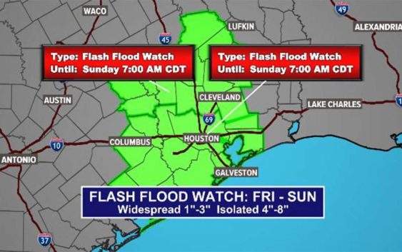
HOUSTON — The National Weather Service has issued a Flash Flood Watch for southeast Texas lasting until 7 a.m. Sunday. Some parts of our area are under a Flash Flood Warning until 9 a.m. today.
Currently, there are no reports of high water spots on Houston’s roadways.
LIVE VIDEO: We’re streaming live, looping radar in the video player above (no audio)
There is now a Flash Flood Warning for Southeastern Grimes County, Harris County, Northwestern Montgomery County, West Central San Jacinto County, Southeastern Walker County and Northeastern Waller County until 9 a.m. Friday.
The areas under the Flash Flood Watch includes the following counties/areas covering a portion of Southeast Texas: Austin, Bolivar Peninsula, Brazoria Islands, Chambers, Coastal Brazoria, Coastal Galveston, Coastal Harris, Coastal Matagorda, Colorado, Fort Bend, Galveston Island, Inland Brazoria, Inland Galveston, Inland Harris, Inland Matagorda, Matagorda Islands, Southern Liberty, Waller and Wharton.
WEATHER ALERTS: Get the KHOU11 mobile app and turn on weather notifications
WEATHER RADAR: Track storms, rain across Southeast Texas
According to the National Weather service, showers and storms will move in from the north early Friday morning. One to three inches of rain is expected, but there could be some training of heavier storms that can cause areas of between four and eight inches. Watch out for areas that are prone to flooding.
Houston weather radar
Timeline: When to expect the heaviest rain, storms in Houston
FRIDAY AM: Expect heavy rain now through 11 a.m. Thunder and rain started entering the downtown area just before 4 a.m. with stronger storms from Cypress, Houston’s west side down through Sugar Land, Rosenberg and into West Columbia. Expect slippery roadways and thunderstorms. A Flash Flood Watch is now in effect for the entire Houston area.
Video: Watch Chita’s latest update
FRIDAY PM: Rain chances decrease a little as we head into the late afternoon and evening hours on Friday, but scattered showers are still possible overnight into Saturday. The rain this afternoon will not be as heavy and widespread as it was Friday morning.
SATURDAY AND SUNDAY: We’re looking at continuing widespread showers with a 60% rain chance. While it may not be as heavy as Friday morning’s rainfall, now is when we will want to keep an eye out for ponding on the roadways and isolated high water spots as the grounds will be very saturated by this point. It’s too soon to know for sure or know which areas will be the most impacted by flooding, if any.
NEXT WEEK: Light scattered showers continue Monday and Tuesday — we won’t have a really nice, sunny day again until Wednesday.