- Habitat for Humanity helping Rock Hill residents assess, clean up storm damage. They are also seeking volunteers
- Smokehouse Creek wildfire victims line up lawsuits against utility
- Will Mexico wildfires impact Houston's air quality?
- The worst tornadoes in North Carolina History
- Hurricane-proof your NC home: Essential steps to weather the storm
Level 2/5 Risk of Severe Weather Tonight
RALEIGH, N.C. (WTVD) — Stay weather away through the evening as storms roll through central NC. Some of those storms could turn severe. The main threat would be a damaging wind gust however large hail and an isolated tornado cannot be ruled out.
Stay weather aware tonight. Scotland county is under a Tornado Watch until 7pm.
In addition, the @ABC11_WTVD viewing area is under a level 2/5 risk of severe weather. The main threat tonight is a damaging wind gust but large hail & an isolated tornado cannot be ruled out. pic.twitter.com/e4BRpeDzxT
— Robert Johnson (@RobJohnsonABC11) May 3, 2021
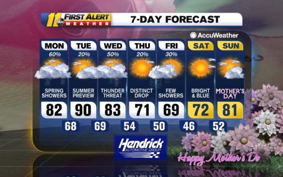
After sunset, showers and storms will begin to end and we’ll be left with a mostly cloudy night with temperatures in the 60s.
Tomorrow will be warm and muggy with highs near 90 in the Triangle and in the low 90s in the Sandhills. More showers and a few storms return Wednesday then Thursday will be much more pleasant with plenty of sunshine and highs in the low 70s. Expect a few showers in the overnight hours.
Friday will start off rather cloudy with clearing skies once we reach into the afternoon.
Mother’s Day weekend looks bright and beautiful with highs in the low 70s on Saturday and low to mid 80s on Sunday.
Be Well & Stay Safe,
Robert Johnson
Copyright © 2021 WTVD-TV. All Rights Reserved.