- Before and after: See Dubai flooding from space
- No evidence of a tornado in Rock Hill, investigation determines
- Marking 15 years since 19,000 acre wildfire destroyed dozens of homes in Horry County
- 'I am so sorry, but we will do it again' Donald Trump calls off Wilmington rally due to severe weather
- Donald Trump forced to call off Wilmington rally due to severe weather
Tuesday's severe weather leaves destruction in its wake
Raleigh, N.C. — Tuesday saw a widespread severe weather event sweep across central North Carolina.
A severe thunderstorm warning was issued earlier in the day for Orange and Durham Counties for about an hour. It ended at 4:30 p.m.
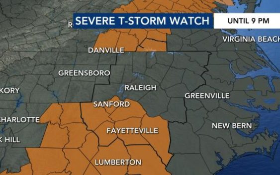
Severe thunderstorm watches were issued for many of our more southern counties, including Sampson, Moore, Lee and Harnett until 9 p.m.
A little after 6 p.m., the National Weather Service upgraded that watch to a severe thunderstorm warning for Cumberland, Hoke, Moore, and Harnett until 9 p.m. That warning was canceled around 6:45 p.m.
“Winds are the biggest threat with this system,” WRAL meteorologist Kat Campbell said.
Raleigh and areas to the south were under a Level 1 risk for severe storms on Tuesday; that risk wass a Level 2 for Greensboro, Danville, Va., and Roanoke Rapids.

A man in Sampson County experienced the wrath of the storms firsthand as a tree fell on to his pickup truck. Joe Chabot of Newton Grove says that after his pickup just sat around for almost two years, today he replaced the battery and moved the truck so he could clean it up.
“By 9 p.m. we are done with the severe weather threat,” Campbell said.
And then this happened.


Timing is everything, they say.
On Wednesday, a cold front will pass through the area.
“Ahead of the front, we should have some decent forcing for storms,” said Campbell, adding that storm chances have increased on Wednesday to 40%.

Wednesday will remain warm with highs in the low-to-mid 80s.
Once the cold front passes, there will be a break from rain and storm chances on Thursday.