- Couple accused of creating videos of young girls using hidden cameras at The Woodlands Mall, Hurricane Harbor
- Couple accused of creating videos with hidden cameras at The Woodlands Mall, Hurricane Harbor
- The Texanist: Texas Gets More Tornadoes Than Any Other State, but Don’t Freak Out
- U.S. Supreme Court says Texans can sue state for flood damage
- This is how many hurricanes NC State researchers predict this year
Severe weather moves on, but patches of rain persist in central NC
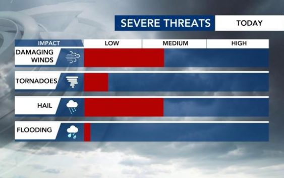
A tornado warning was issued Monday for Orange, Chatham and Alamance counties until 5:15 p.m. as severe weather swept its way across central North Carolina.

The Triangle experienced a level 2 risk for a portion of the afternoon and evening Monday. The level 2 threat was in effect for Raleigh, Fayetteville, much of the Sandhills region as well as east of Interstate 95.
A severe thunderstorm warning was issued until 6 p.m. for many counties in the WRAL viewing area, including the Triangle. The warning was canceled for Orange and Durham counties at 5:45 p.m.
Hail has been reported throughout central NC as the scattered storms move through. WRAL viewers reported hail in parts of Orange, Chatham and Alamance counties, among others.

The severe threat moved out of the are around 8:30 p.m. but left patches of rain behind.
“If you need rain, areas from Raleigh and southward should see period of showers through midnight,” Mike Maze said.
The cold front that brings us the thunderstorms will also cool us down.

“This will be the last warm day for a while,” WRAL meteorologist Aimee Wilmoth said. “After Tuesday, we stay in the 60s for our highs through Friday. There’s some cool air back behind that front that’s coming through this afternoon.”
We’ll be drier Tuesday for the Durham Bulls Opening Day coverage. No problems there! Isolated rain chances will be rather sporadic Wednesday to Friday and are dependent on the strength of an area of high pressure as that can keep a lot of that rain south.
