- Couple accused of creating videos of young girls using hidden cameras at The Woodlands Mall, Hurricane Harbor
- Couple accused of creating videos with hidden cameras at The Woodlands Mall, Hurricane Harbor
- The Texanist: Texas Gets More Tornadoes Than Any Other State, but Don’t Freak Out
- U.S. Supreme Court says Texans can sue state for flood damage
- This is how many hurricanes NC State researchers predict this year
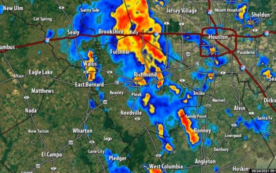
Flash Flood Warning for Harris, Montgomery counties until 3:45 p.m.
It’s rained 17 out of the last 24 days so the ground is very saturated and we’ve already seen some traffic nightmares around Houston.
HOUSTON — Thunderstorms are rolling through the area bringing heavy rain and some traffic headaches.
As of 12:45 p.m. — A Flash Flood Warning has been issued for Harris and Montgomery counties until 3:45 p.m.; all area counties remain under a Flash Flood Watch until 9 p.m.
There are already flooded roadways in the Houston area. Click here for a list of high water locations.
There’s a 70 percent change of more rain throughout the day, with temperatures staying in the 70s, according to the KHOU 11 Weather Team.
It’s rained 18 out of the last 24 days so the ground is very saturated and we’ve already seen high water on some roadways, including 288 and I-45 North.
> Watch the latest forecast from Blake Mathews that appeared on KHOU 11 News at noon.
Flash Flood Watch
A Flash Flood Watch is in effect until 9 p.m. for Austin, Coastal Brazoria, Fort Bend, Grimes, Inland Brazoria, Inland Harris, Montgomery, Waller and Washington counties.
A band of storms from the Freeport area are feeding up into Fort Bend and Harris counties and will continue to do so through early afternoon. Repeat rain through the day means rainfall totals of 2 to 3 inches in many areas. Isolated areas may see up to 6 inches.
Houston forecast
Tuesday, the rain chances stay high at 60 percent. By Wednesday, rain chances drop down to about 30 percent, then high pressure moves in to keep the rain chances down and the temperatures start to rise leading into the Memorial Day weekend.
Right now, long-range models have us being spared any shower activity for Memorial Day itself. Stay tuned!