- Couple accused of creating videos of young girls using hidden cameras at The Woodlands Mall, Hurricane Harbor
- Couple accused of creating videos with hidden cameras at The Woodlands Mall, Hurricane Harbor
- The Texanist: Texas Gets More Tornadoes Than Any Other State, but Don’t Freak Out
- U.S. Supreme Court says Texans can sue state for flood damage
- This is how many hurricanes NC State researchers predict this year
Tropical Storm Claudette forms in Gulf of Mexico, could bring remnants to NC
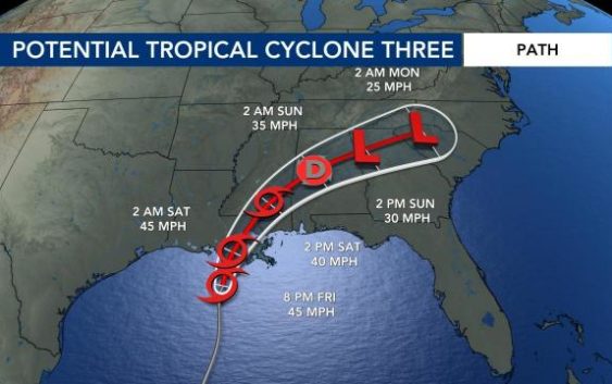
Raleigh, N.C. — Tropical Storm Claudette has formed in the Gulf of Mexico and is expected to bring rain and strong storms to parts of the southeast, including North Carolina.
Claudette formed early Saturday morning. The storm’s winds strengthened to 45 miles per hour on Friday night. The system is moving north-northeast at 12 miles per hour.
Rain has begun falling along the Gulf Coast, and there is a high risk for flash flooding for some Gulf Coast states on Friday and Saturday.
“The system is very lop-sided, so all of the rain is east of the ‘center,'” explained WRAL meteorologist Kat Campbell.
The National Weather Service said the system is expected to produce heavy rain and flash flooding along the central Gulf coast. Tropical storm conditions are expected to start Friday from Intracoastal City, La. to western Florida.
The system is moving north on a path that could take it over Louisiana Saturday and across the southeast and into the mountains of western North Carolina by the end of the coming weekend.
Several models have the system going right over central North Carolina, meaning we could see heavy rain south and east of the track.
“By the time it gets to us, it would be a remnant low pressure system,” said Campbell.
The amounts will depend on the center of the system track. The timing of the rain looks to get here on Sunday evening, so get your Father’s Day plans in early. The rain looks to stick around on Monday morning before moving out on Monday afternoon.
There should be a break in the rain Monday night, but a cold front Tuesday will deliver another round of showers and thunderstorms.
Rainfall totals could reach 1.5 inches by Tuesday in the Triangle. The heaviest amounts of rain would appear in our southwestern counties with severe weather possible in the southeast half of the viewing area.

“Rain will be more impactful than wind, but we could see some gusts up to 35 miles per hour,” said Campbell, adding that the tornado threat will depend on the exact track of the system.
“Right now, it appears that if there is a risk – it will stay south of the Triangle,” added Campbell.
