- The Texanist: Texas Gets More Tornadoes Than Any Other State, but Don’t Freak Out
- U.S. Supreme Court says Texans can sue state for flood damage
- This is how many hurricanes NC State researchers predict this year
- NC State researchers predict above-average hurricane season
- Supreme Court rules in favor of property owners suing Texas over flood damage
Tropical storm watch issued for North Carolina coastal waters as Elsa nears Florida

The National Weather Service has issued a Tropical Storm Watch for North Carolina’s coastal waters until further notice, as Tropical Storm Elsa nears Florida.
Swells of 5 to 8 feet are possible, along with tropical storm force winds.
Elsa is expected to gain enough strength over the open water of the Gulf of Mexico to make landfall as a Category 1 hurricane Tuesday night just north of Tampa, Fla., according to the 5 p.m. update from the National Hurricane Center.
The latest update showed the storm had maximum sustained winds of 70 mph.
Elsa was moving north at 10 mph on a track that would take it over Jacksonville, Fla. Tropical storm watches and warnings and some tornado warnings were issued along Florida’s west coast. Tropical storm watches are issued for the coast of South Carolina.
The latest update from NHC said tropical storm conditions were occuring over parts of the Florida keys, and would spread north along the west coast of Florida trough Wednesday morning.
Elsa will pick up pace and weaken as it moves further onto land across the southeast corner of Georgia and through South Carolina and North Carolina.
By Thursday morning, rain from Elsa arrives in the southern counties of central North Carolina, including Scotland and Richmond. The storm track brings it across North Carolina just southeast of Raleigh as a tropical depression before an eastward turn takes it back out over the Atlantic Ocean.
The forecast cone shows the storm could cross North Carolina anywhere from the Triad to the coast.
Heavy rain will be widespread across central and eastern North Carolina through the late afternoon, with the chance for lighter showers continuing until about 8 p.m.
A Level 1 threat for severe weather is in place for the coastal plain for Thursday. Parts of North Carolina could see up to three to four inches of rain.
“We could have some wind gusts up to 35 miles per hour and perhaps some isolated tornadoes as well,” said WRAL meteorologist Aimee Wilmoth.
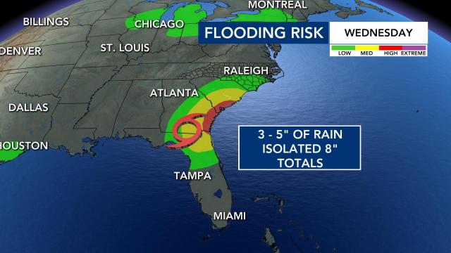
The storm also presents a significant flooding risk, largely east of the Triangle. Most of eastern North Carolina is under a medium risk for flooding.
“The track of Elsa is farther west now, with the center of the tropical depression moving over us on Thursday,” said WRAL meteorologist Mike Maze. “On this track we have a greater risk for isolated tornadoes and rainfall.”

