- Couple accused of creating videos of young girls using hidden cameras at The Woodlands Mall, Hurricane Harbor
- Couple accused of creating videos with hidden cameras at The Woodlands Mall, Hurricane Harbor
- The Texanist: Texas Gets More Tornadoes Than Any Other State, but Don’t Freak Out
- U.S. Supreme Court says Texans can sue state for flood damage
- This is how many hurricanes NC State researchers predict this year
Flood advisory in effect west of the Triangle

A flood advisory is in effect for Durham and Orange counties until 2 p.m. Monday as rain soaks the Triangle.
Widespread rain covered the radar Monday morning with only a few breaks in the showers. The rain is expected to become heavier throughout the day, tapering off around the evening commute.
“Just expect this to continue for most of the day,” said WRAL meteorologist Elizabeth Gardner.
Between 2 and 3 inches of rain fell west of Raleigh, and the National Weather Service indicated more rain could lead to isolated flooding, in Durham, Hillsborough, Rougemont, Bahama and in the areas of Eno River State Park and Lake Michie.
There will be some lightning and thunder, but the biggest impact will likely be heavy rain creating a possibility of flooding.
Track rain with DUALDoppler5000

Storm chances will keep temperatures slightly cooler, with highs in the upper 70s on Monday.
According to Gardner, the rain will stall to our south, bringing another chance for rain Tuesday. Between 2 and 3 inches of rain will be possible south of the Triangle, she said.
The day will also be warmer, with a high in the low 80s.

Plenty of rain so far this summer
The rainfall totals are likely to start adding up over the next few days.
“We could get some heavy rain from some of these storms” said Sheerwood. “We could rack up around two inches of rainfall as we look at the next five days.”
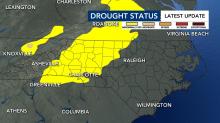
As of Thursday, no part of North Carolina is in a drought, which is great progress from where we stood during the spring. Last week, 48% of the state was abnormally dry. This week, just 26% of the state is abnormally dry.
Since June 1, Raleigh has seen nearly a foot of rain – 11.35 inches. Fayetteville has seen 9.41 inches of rain within that same time frame. Raleigh officially saw 3.38 inches of rain on Thursday.