- Couple accused of creating videos of young girls using hidden cameras at The Woodlands Mall, Hurricane Harbor
- Couple accused of creating videos with hidden cameras at The Woodlands Mall, Hurricane Harbor
- The Texanist: Texas Gets More Tornadoes Than Any Other State, but Don’t Freak Out
- U.S. Supreme Court says Texans can sue state for flood damage
- This is how many hurricanes NC State researchers predict this year
Parts of central North Carolina at risk for storms, hail and even isolated tornado
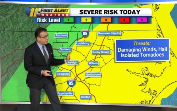
Parts of central North Carolina will have a slight risk for storms throughout Sunday.
First Alert Meteorologist Steve Stewart said stalled frontal boundary will become the focus for unsettled weather today.
Upper-level energy will stir up showers and thunderstorm activity as low-level moisture gets drawn northward and the frontal boundary buckles northward.
Most of the activity activity will remain north of us this morning, rumbling across southern Virginia. However, in the afternoon, we can expect some thunderstorms to develop across eastern North Carolina that could become severe from southeastern Virginia across eastern North Carolina into northeastern South Carolina.
The strongest of these afternoon thunderstorms will be capable of damaging winds, downpours and possibly even an isolated tornado.
As the upper-level energy pushes to the east tonight it will spin up an area of low pressure off the Delmarva Peninsula coast. As this low spins up, that frontal boundary will be driven southward again, allowing northern areas to dry out with perhaps a few lingering showers and thunderstorms to the south. There will be a brief respite from rain however, as the next upper-level disturbance crosses the area on Tuesday, forcing the front to ripple northward once again.
This will be the first in a series of disturbances aloft to round the base of a broad upper-level trough which will carve out a spot across the East.
Copyright © 2021 WTVD-TV. All Rights Reserved.