- Couple accused of creating videos of young girls using hidden cameras at The Woodlands Mall, Hurricane Harbor
- Couple accused of creating videos with hidden cameras at The Woodlands Mall, Hurricane Harbor
- The Texanist: Texas Gets More Tornadoes Than Any Other State, but Don’t Freak Out
- U.S. Supreme Court says Texans can sue state for flood damage
- This is how many hurricanes NC State researchers predict this year
Tropical Storm Fred: Latest projected path, models and potential impacts to Florida
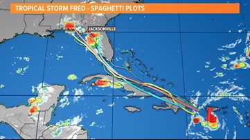
As Tropical Storm Fred moves over Hispaniola on Wednesday, it will weaken. The First Coast can anticipate increased storm chances by Sunday into Monday.
JACKSONVILLE, Fla. — Tropical Storm Fred formed in the Caribbean Sea late Tuesday making it the earliest 6th Atlantic named storm on record. The average date for the 6th Atlantic named storm to form is August 28, so the 2021 hurricane season remains ahead of “schedule.”
Fred may impact the First Coast by late this weekend into early next week. The forecast is becoming more clear with confidence that this system’s core will remain well west of the Jacksonville area. Landfall is expected some time on Monday near Apalachicola, but really anywhere from Pensacola to Cedar Key cannot be ruled out.
With that being said, impacts from Fred will continue to be fine-tuned for the First Coast. The majority of those impacts will be felt Sunday through Monday, and possibly into Tuesday. As of now, we can expect the following conditions:
- Breezy with sustained winds up to 20+ mph (40 mph gusts) inland; 10+ mph (30 mph gusts) along the coast
- Rounds of tropical downpours with 4-6″ of rain inland; 2″+ closer to the coast with localized, higher amounts
- A few severe storms in outer rain bands stretching all the way to the Beaches
- 58+ mph wind gusts
- Isolated tornadoes
- A few severe storms in outer rain bands stretching all the way to the Beaches
- Prolonged river flooding, mainly for the Suwannee River Valley region and the St. Marys River at Macclenny (several gauges already at flood stage, but thankfully have been trending down this week with the drier weather)
- Isolated urban and street flooding
Keep in mind (at this time):
- There is NOT a surge concern
- There is NOT a concern for bridges to close
Now is the time to stock up on supply kits and review your family’s emergency plan, especially with the most active part of the Atlantic hurricane season getting underway.
As of the 8 a.m. advisory on Wednesday, the center of Fred was just south of the eastern Dominican Republic or about 50 miles southeast of Santo Domingo. Maximum sustained winds were at 40 mph, but Hurricane Hunters investigating the storm have recently found stronger winds. It was moving west-northwest at 16 mph. Fred has yet to cross over the Caribbean’s highest, most mountainous terrain which is Pico Duarte (10,164 ft.) of Hispaniola. The forecast will be in even better focus by Thursday afternoon once it emerges north of Cuba.
Tropical Storm Fred: Latest projected path, models and potential impacts to Florida

ANYTHING ELSE OUT THERE? A tropical wave located over the eastern tropical Atlantic several hundred miles west-southwest of the Cabo Verde Islands continues to produce disorganized showers and thunderstorms. Some gradual development of this system is possible, and a tropical depression could form by early next week while moving generally westward across the tropical Atlantic near 20 mph. This system could reach portions of the Leeward Islands by late Saturday.
SEASONAL OUTLOOK: NOAA’s outlook calls for 15-21 named storms, 7-10 hurricanes, and 3-5 major hurricanes in total.
“After a record-setting start, the 2021 Atlantic hurricane season does not show any signs of relenting as it enters the peak months ahead,” said Rick Spinrad, Ph.D., NOAA administrator. “NOAA will continue to provide the science and services that are foundational to keeping communities prepared for any threatening storm.”
Looking deeper into the season, the Climate Prediction Center has issued a La Niña Watch with La Niña potentially emerging from September through November. La Niña can help make atmospheric conditions more conducive for tropical cyclones to form the Atlantic, and less conducive in the Eastern Pacific. If 2021 is any indicator so far of what lies ahead this season, it could continue to be an active year. As of the beginning of July, there have been five named storms breaking the previous record set just last year. In August, the Climate Prediction Center will issue an updated hurricane outlook.
Hurricane season is here and it’s time to be prepared if you aren’t already. Make sure you have had conversations with your loved ones about what you would do if a storm were to threaten.
This year, NOAA released the new seasonal averages for the Atlantic basin. According to the 30-year data from 1991 to 2020, the new averages include 14 named storms, 7 hurricanes, and 3 major hurricanes. The previous Atlantic storm averages, based on the period from 1981 to 2010, were 12 named storms, 6 hurricanes, and 3 major hurricanes. The averages from 1951-1980 , were 11 named storms, 5 hurricanes, and 1 major.
Hurricane safety and preparedness are critically important even before the season begins on June 1. NOAA’s National Weather Service provides resources to prepare for hurricane hazards and real-time updates about active weather systems from the National Hurricane Center at www.hurricanes.gov.
The Atlantic hurricane season officially runs from June 1 to November 30.
Download the First Coast News app and sign up for severe weather alerts