- Couple accused of creating videos of young girls using hidden cameras at The Woodlands Mall, Hurricane Harbor
- Couple accused of creating videos with hidden cameras at The Woodlands Mall, Hurricane Harbor
- The Texanist: Texas Gets More Tornadoes Than Any Other State, but Don’t Freak Out
- U.S. Supreme Court says Texans can sue state for flood damage
- This is how many hurricanes NC State researchers predict this year
Ida intensifies to a Category 4, expected to make landfall in Louisiana as a major hurricane
Hurricane Ida is forecast to go through rapid intensification as it nears the Louisiana coast tomorrow. A Category 4 hurricane is possible at landfall.
CHARLOTTE, N.C. — The historic peak of hurricane season is September 10, but it is late August and September that some of the more notable storms have formed and even impacted the Carolinas.
Hurricane Ida is expected to impact the northern Gulf coast, so preparations for life and property should be rushed to completion. Here in the Carolinas, notable impacts aren’t expected but we could have additional cloud cover and rain mid-next week.
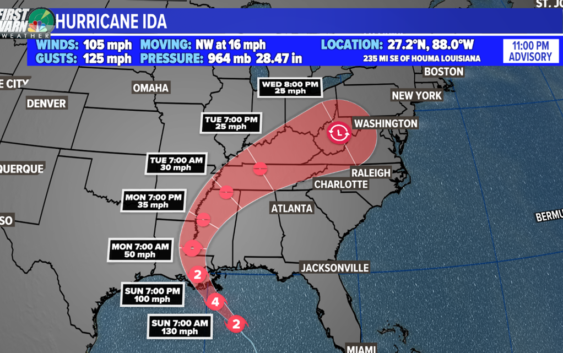
Hurricane Ida
Location: 235 miles southeast of Houma, Louisiana
Potential Impacts: United States northern Gulf coast: including Louisiana, Mississippi, Alabama, and the western Florida panhandle
What has happened:
On August 26th, Tropical storm Ida was born and it strengthened to a Category 1 hurricane just after 1 p.m. August 27th. Shortly after, the storm made landfall on the Isle of Youth, the second-largest Cuban island. The second landfall was near Pinar Del Rio, Cuba with sustained winds at 80 mph. It was over the island for about 3-4 hours.
The Forecast:
Hurricane Ida will be the major story Sunday and one for the history books. Ida is expected to rapidly intensity to a Category 4 major hurricane before landfall. Storm surge and hurricane warnings have been issued for the northern Gulf coast.
Now through Sunday Morning: Ida will go into a process called “rapid intensification” as it moves through the Gulf of Mexico. These warm waters allow for hurricanes historically to thrive and grow. Two examples are Hurricane Katrina (2005) and Hurricane Michael (2018). So what will happen?
- Central pressure will drop which strengthens the wind field
- The eye wall will form turning Ida into a classic looking strong hurricane
- Sustained winds will increase over 35 mph in a 24 hour period.
- Hurricane Ida will become a major hurricane peaking up to Category 4 strength of 140+ mph
Storm Surge:
Historically, storm surge is the largest threat to life and property within a tropical cyclone. The water level rise due to Ida is expected to be the worst from Morgan City, LA to the mouth of the Mississippi River where the water levels could peak between 10 to 15 feet.
A Storm Surge Warning is in effect for east of Rockefeller Wildlife Refuge, Louisiana to the Alabama/Florida border, Vermilion Bay, Lake Borgne, Lake Pontchartrain, Lake Maurepas, and Mobile Bay.
A Hurricane Warning is in effect for Intracoastal City, Louisiana to the mouth of the Pearl River, Lake Pontchartrain, Lake Maurepas, and Metropolitan New Orleans.
A Tropical Storm Warning is in effect for Cameron, Louisiana to west of Intracoastal City, Louisiana, the mouth of the Pearl River to the Alabama/Florida border.
Rainfall:
One of the worst features of a hurricane is the amount of rain it brings to an area. Louisiana is incredibly low in elevation for flooding and storm surge is magnified. The peak rain around the core is estimated to be up to 15″+. Also 3-10″ of rain will spread across Mississippi.
Tropical Depression Ten
Tropical Depression Ten formed in the central Atlantic Ocean Saturday morning. The system is expected to drift northward over the next few days when it could become a tropical storm.
It’s expected to stay well east of the Lesser Antilles. Next storm name on the list is Julian.
Tropical Depression Eleven
Tropical Depression Eleven formed in the sub-tropical Atlantic Ocean Saturday evening. Eleven is expected to become a short-lived tropical storm.
It is no threat to the United States. It’s racing against Ten for our next named storm.
Tropical Wave
Location: over Africa
Development Chance: 70% within the next five days
This is a new area to monitor in the Atlantic Basin. A tropical wave is expected to emerge off the African coast by mid-next week. Conditions will be marginally conducive for development.
It’s much too early to know what could happen with this disturbance. Stay tuned for updates!