- Severe weather leads to fallen trees, car crashes and flooding around the Triangle
- New video shows vehicles being swept away in historic, deadly flash floods in SA on June 12
- $40 million to go to underserved SC counties for Hurricane Helene recovery. Here's what you need to know.
- Family honors Air Force veteran Derwin Anderson Jr. after he died in June flash floods
- City of Wilmington addresses flooding on New Centre Drive
Tropical Storm Nicholas set to make landfall, two more named storms possible later this week

We’re deep into the most active month of hurricane season and the WCNC Charlotte weather team is tracking three systems.
CHARLOTTE, N.C. —
Tropical Storm Nicholas
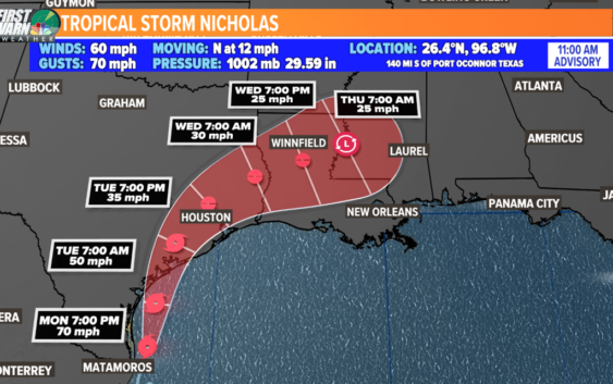
Tropical Storm Nicholas is the newest named storm in the Atlantic basin that formed over the weekend. The 14th named storm this hurricane season is currently a tropical storm with maximum sustained winds of 60 mph with gusts of 70 mph in the southern Gulf of Mexico.
Track:
Nicholas is set to make landfall Tuesday morning near Corpus Christi, Texas. Sustained winds will be near hurricane strength at 70 mph. This will be very close to becoming a hurricane before landfall. It will be over Houston by Tuesday night into Wednesday morning. The biggest problem with Nicholas, is that it slows down over land. Flash flooding will be tremendous from this system and it consequently will affect areas that got plagued in 2017 from Harvey and for parts of Louisiana that are more recently, recovering from Ida.
Main Threat: Heavy rain and Flooding
The biggest threat with this system is rainfall and flooding. This track is too slow, and are lucky it is not forecasted to stall like Harvey did. However, a slow pace like this one will still bring 10-15″ for a lot of communities over 2-3 days with some closer to 20″ by the end of this event.
Storm Surge:
The combination of high tide and storm surge will allow for a water level rise of 2 to 4 feet from the mouth of the Rio Grande to High Island, Texas, Baffin Bay, Corpus Christi Bay, Aransas Bay, San Antonio Bay, Matagorda Bay, and Galveston Bay.
A Storm Surge Watch is in effect for coastal areas near Houston, and a Storm Surge Warning is in effect for the Texas coastline.
Invest 95-L
This first wave is located off the coast of Africa. The tropical disturbance is moving on a westward path. There’s a 80% chance it will develop into a tropical depression or storm over the next two to five days when it drives into more favorable conditions. It will be a long wait until this gets close to anything but since it is marching due west, it could become a major watch by this time next week.
Invest 97-L
Gradual development is possible and the National Hurricane Center is giving it a 50% chance of development over the next two to five days.
This will be dangerously close to the Carolinas, but we have some things working in our favor. Long-term forecast models indicate the system will stay away from the United States east coast due to a strong ridge of high pressure and approaching cold front. This is subject to change, so we’ll monitor closely.
The next two names on the 2021 Atlantic hurricane list are Odette and Peter.