- The Texanist: Texas Gets More Tornadoes Than Any Other State, but Don’t Freak Out
- U.S. Supreme Court says Texans can sue state for flood damage
- This is how many hurricanes NC State researchers predict this year
- NC State researchers predict above-average hurricane season
- Supreme Court rules in favor of property owners suing Texas over flood damage
Standing water, minor flooding reported in Triangle as waves of brief, heavy rain interrupt commute
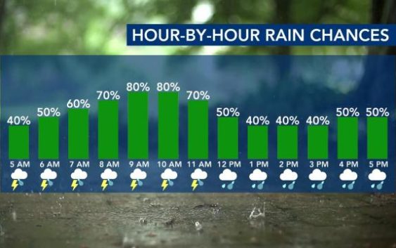
Raleigh, N.C. — Thursday will be a mostly cloudy day with scattered to widespread rain developing and moving through our area this morning and afternoon.
While central North Carolina will see only scattered rain during the first half of the day, counties east of the Triangle are under a Level 1 risk for severe weather Thursday afternoon, where a few strong storms are possible through the evening as a cold front moves across the region.
Wind damage east of Interstate 95 will be the biggest threat from the storms, but WRAL meteorologist Elizabeth Gardner said such conditions are more likely closer to the N.C. coast.
Rain passing through the area during the morning commute will come in waves, and there could be brief, heavy downpours, Gardner explained.
By 7 a.m., downpours resulted in standing water on U.S. Highway 1 South at Cary Parkway and on Interstate-540 West between Falls of Neuse Road and Six Forks Road. Multiple crashes were reported, including one on Wade Avenue between Blue Ridge Road and Edwards Mill Road.
Conditions will be drier in the afternoon for the Triangle, but “showers may still be possible across the eastern half of the area for the evening commute,” WRAL meteorologist Zach Maloch said.

A high around 70 degrees is expected on Thursday.

Conditions will become drier Thursday night and for Friday, which will be a cooler day with a chilly start. Skies will be cloudy Friday, and temperatures will remain in the mid 60s.
It could be a breezy day, with possible wind gusts up to 25 mph.
Lows will start out in the low 40s for Saturday morning, and there is a chance for rain during the first half of the day. Temperatures will be cooler, in the low 60s.

More sun and drier conditions emerge for Sunday, but temperatures will start in the 30s. The high for the day will reach the upper 50s or low 60s.
Temperatures could be near freezing overnight Sunday into Monday, but the first part of the new work week will stay mild, with highs in the low 60s.

Eager to get the garden going?
Wondering if it’s okay to start planting? Temperatures will stay spring-like for a while, but cooler temperatures are ahead. We’re expecting cooler than average temperatures next week, according to meteorologists.

Our average last freeze comes in mid-April.