- The Texanist: Texas Gets More Tornadoes Than Any Other State, but Don’t Freak Out
- U.S. Supreme Court says Texans can sue state for flood damage
- This is how many hurricanes NC State researchers predict this year
- NC State researchers predict above-average hurricane season
- Supreme Court rules in favor of property owners suing Texas over flood damage
Wake, Durham counties under flood advisory as heavy rain pours down across the Triangle
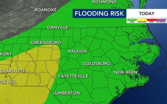
Raleigh, N.C. — There is a Level 1 risk for severe weather for Wake County and areas south and heavy rain is expected until around 10 p.m.
Communities south and east of Fayetteville are under a Level 2 risk for severe storms. The greatest threat for severe weather is along the North Carolina-South Carolina border and along the coast.
A flood advisory was issued on Tuesday night for Alamance, Durham, Orange and Wake counties.
There is a chance for damaging winds and heavy rain in central North Carolina from 7 p.m. to 11 p.m. Weather conditions do favor a tornado, but WRAL meteorologist Brian Shrader said that our chance for a tornado is low.
“That threat stays just south of our viewing area, closer to the coast,” said WRAL meteorologist Kat Campbell.
Most of the heavy rain will dissipate when it hits the Triangle as storms moves into more stable air.
“We are going to see heavy rain with this, even if we don’t have any severe storms,” Shrader said.
Winds could gust up to 40 mph this evening and it should stay windy until midnight.

Isolated showers will likely linger until 2 a.m. in the northern half of our viewing area.
There were several tornado watches issued for parts of South Carolina near Columbia, including a confirmed tornado in Allentown, around 100 miles from the North Carolina border.
A tornado watch was issued for areas along the North Carolina coast, including Wilmington.
Storms should leave the area by 8 a.m. on Wednesday. Wednesday will be partly to mostly cloudy morning with a few lingering showers possible for the morning commute, but turning drier through the morning.
There is a 20% chance for rain on Wednesday, when temperatures soar into the low 80s.
While Wednesday is looking drier, another batch of rain comes our way for the second half of Thursday.

The Triangle is under a Level 1 risk for severe weather again on Thursday, with areas to the west under a Level 2 risk. Right now it looks like storms will be scattered throughout the afternoon, but the ones that form could become strong to severe.
Friday will be a dry, mild day, with a high in the mid 60s. Saturday and Sunday will be sunny but cooler, with highs in the low 60s. A stray shower will be possible Saturday night.
