- Southport reflects on Hurricane Isaias five years later
- Texas bills increasing youth camp safety face long odds, even after Hill Country floods
- Kerr County officials failed to follow certain aspects of disaster plan during Texas floods
- “Nobody came”: Hill Country flooding survivors recount anguish, neglect during emotional hearing
- Top two Kerr County emergency officials say they were asleep as July 4 floods struck
Panovich: Severe weather risk going down overnight, but not away

While the risk is low, it’s not zero.
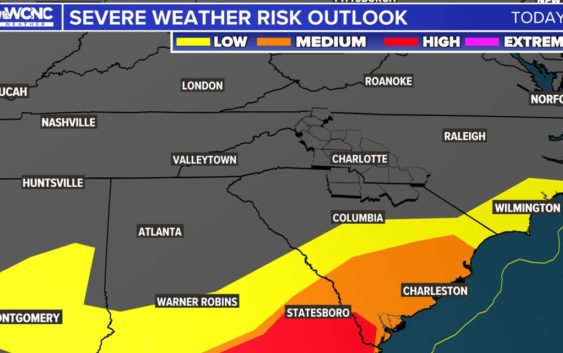
CHARLOTTE, N.C. — The Carolinas will be at risk for more severe weather late Wednesday into early Thursday, including an isolated tornado, as the second wave of thunderstorms moves over the Charlotte area.
In a 9 p.m. update, Chief Meteorologist Brad Panovich said the risk is going down but isn’t a non-zero threat.
“There’s still some ingredients out there tonight,” Panovich said. “I certainly believe it’s low — I just don’t think it’s zero.”
The storms won’t be as widespread as they were on Tuesday, but the few storms that do manage to develop have the potential to become severe.
Panovich said while he isn’t overly concerned with the threat overnight, it’s still a good idea to keep your phone charged and the volume up.
The setup
Wednesday was sunny, warm, and breezy as humid and warm air streamed in from the South all day long.
“There really will not be a lot going on during the day,” Panovich explained as a warning to not dismiss the threat for later.
This environment, combined with the arrival of a strong cold front overnight, means better ingredients will be placed for strong storms.
“The storms are really scattered [tonight],” Panovich said in a video forecast on WCNC Charlotte’s Weather IQ YouTube channel. “While there’s not a ton of them, the chances of them rotating are pretty significant.”
Timing
Due to the scattered nature of the storms, it’s possible some communities never see a storm. Meanwhile, others could see a strong-to-severe thunderstorm.
“When you look at the forecast, the timing is still around 2 a.m.,” Panovich said. “So there’s going to be some type of storms moving through.”
Panovich said the risk of severe weather impacts has lowered all around, but damaging winds would still be the main concern.
Overnight alerts
Due to the late-night hour of this storm risk, the WCNC Charlotte Weather Team is again stressing the importance of having multiple ways to receive severe weather alerts, including a NOAA weather radio and the WCNC app.
The WCNC Charlotte Weather Team will monitor weather conditions throughout the night.
Impacts
The risk of damaging winds is also present.
Stay Weather Aware: What to do during a tornado warning
When at home, you and your family need to go to a safe place. First, go to the lowest level of your home immediately. A basement is ideal, but if you don’t have one, find the most interior room of your house away from windows.
Crouch on the floor and cover your head as much as you can. Brad Panovich’s family keeps helmets in their safe space, along with other supplies for a tornado warning.
Your safe place should have a flashlight, as well as food and water. You should always wear shoes because if there is damage, you may have to walk through nails or broken glass.