- List of hurricane names 2024
- Homeowners insurance doesn't cover floods: How to protect your home in North Carolina
- Before and after: See Dubai flooding from space
- No evidence of a tornado in Rock Hill, investigation determines
- Marking 15 years since 19,000 acre wildfire destroyed dozens of homes in Horry County
Tornado Warning canceled for Wayne County, Tornado Watch continues into evening for eastern counties
Raleigh, N.C. — Level 1 and Level 2 risks for severe weather are in place across North Carolina for Thursday afternoon and evening.
A Tornado Warning initially in effect for Wayne County was canceled shortly after.
The Tornado Watch in central North Carolina was canceled earlier Monday evening.
Edgecombe, Halifax, Johnston, Nash, Wayne and Wilson counties are still currently under a Tornado Watch until 9 p.m.
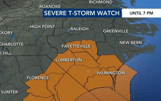
A Severe Thunderstorm Watch was also issued until 7 PM for Fayetteville and Cumberland Counties and southeast toward the coast.
A lightning strike in Johnston County caused a house fire Thursday evening.
While authorities say the family was home when the strike happened, no one was injured in the fire.
Hail was reported in Rocky Mount and areas nearby early Monday evening.
Flooding is also a concern even as the storms pass.
Edgecombe, Halifax, Johnston, Nash, and Wilson counties are under a Flood Advisory until 8:00 p.m.
Friday will be a cooler day, with highs in the mid 60s. It will be a pleasant but breezy day to get outdoors, with mostly sunny skies and wind gusts up to 30 mph.

Saturday will become cooler and partly cloudy, “not as breezy, but it will be a chilly spring day,” Maloch explained. Highs may not make it out of the 50s, and a stray sprinkle or shower will be possible during the daytime hours, but the day will be dry overall.

Some patchy frost will be possible overnight into Sunday morning. Sunday will be a dry day with a high around 60 degrees.

The first half of the new work week is already looking warmer than the weekend, with highs in the upper 70s and low 80s.