- Couple accused of creating videos of young girls using hidden cameras at The Woodlands Mall, Hurricane Harbor
- Couple accused of creating videos with hidden cameras at The Woodlands Mall, Hurricane Harbor
- The Texanist: Texas Gets More Tornadoes Than Any Other State, but Don’t Freak Out
- U.S. Supreme Court says Texans can sue state for flood damage
- This is how many hurricanes NC State researchers predict this year
Flooding, hail and high winds possible heading into Memorial Day weekend
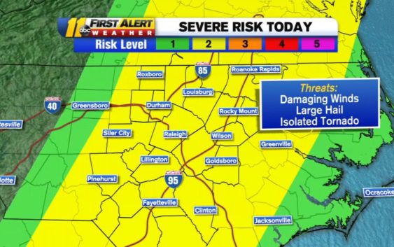
RALEIGH, N.C. (WTVD) — A severe weather risk on Friday could bring isolated tornadoes, hail, high winds and flooding to areas of the Triangle.
You can expect to see scattered showers and some thunderstorm activity Friday morning.
The main brunt of the system will arrive toward noon with flooding downpours being the biggest risk we face.
However, a damaging wind risk is possible as well, and even a tornado is not out of the question though the risk is fairly low. Hail is also possible.
The storms should wind down in the evening as the system pushes to the east, showers/thunder can still be ongoing along the coast.
The good news when it comes to weather is that this weekend looks great for outdoor activities you may have planned. As the system moves off the coast, we’ll see partly sunny to mostly skies in the Triangle.
Temperatures will rebound a bit, back into the low 80s and the humidity should be at fairly comfortable levels.
Dry weather and sunshine will continue for Sunday into Memorial Day. This should give us a nice extended holiday weekend.
Copyright © 2022 WTVD-TV. All Rights Reserved.