- Southport reflects on Hurricane Isaias five years later
- Texas bills increasing youth camp safety face long odds, even after Hill Country floods
- Kerr County officials failed to follow certain aspects of disaster plan during Texas floods
- “Nobody came”: Hill Country flooding survivors recount anguish, neglect during emotional hearing
- Top two Kerr County emergency officials say they were asleep as July 4 floods struck
Storms popping up that could bring street flooding, damaging winds across Houston area | Timeline

Torrential rain and one or two gusty thunderstorms are possible as a cold front approaches the area and you can expect a messy drive home today.
HOUSTON — Those storms we’ve been telling you about have begun bubbling up across the Greater Houston Area.
You can expect heavy rain with possible street flooding so be ready for a messy drive home. Damaging winds are also possible. Tell the boss you need to leave a little early today!
Folks in Kingwood said they’ve already seen hail.
The thunderstorms are expected to stick around until 7 p.m. or so tonight when the front pushes out.
The cold front’s interaction with the hot and humid air mass in place will produce widespread storms and downpours, potentially with gusty winds. Rainfall totals may be grand in some locations, topping a few inches as the front rolls through and then stalls to our south.
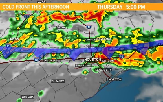
Timeline of Thursday thunderstorms
2PM: The line of thunderstorms began rolling through northern Harris county.
5PM: The line of thunderstorms continues to push south, reaching the I-10 corridor.
6PM: The line pushes south of I-10… steady rain still falling along the I-10 corridor.
7PM: Storms drive farther south closer to the coast.
The line of storms could produce up to 3 inches of rain in some areas, which could lead to street flooding. In addition to the rain, expect lots of lightning.
Strong to severe storms are possible as the line arrives, similar to what we saw last week.
Wind gusts could reach 40 to 50 mph in spots.
It’s not a strong setup for tornadoes. However, an isolated tornado is not out of the question
Follow the KHOU 11 Weather Team for daily updates: