- Couple accused of creating videos of young girls using hidden cameras at The Woodlands Mall, Hurricane Harbor
- Couple accused of creating videos with hidden cameras at The Woodlands Mall, Hurricane Harbor
- The Texanist: Texas Gets More Tornadoes Than Any Other State, but Don’t Freak Out
- U.S. Supreme Court says Texans can sue state for flood damage
- This is how many hurricanes NC State researchers predict this year
Hurricane Ian nears historic Category 5 status as it nears Florida landfall: Live updates
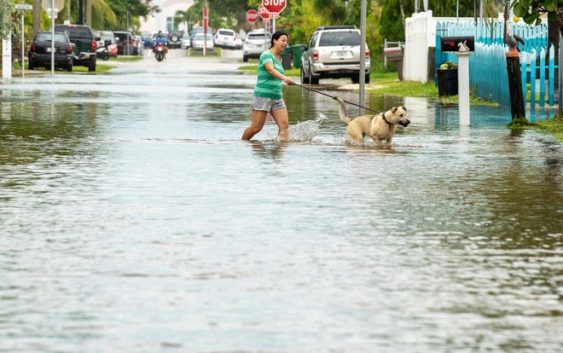
Hurricane Ian strengthened into an “extremely dangerous” Category 4 storm and roared to the brink of Category 5 status, its maximum sustained winds blasting at 155 mph as the west coast of Florida braced for landfall Wednesday afternoon.
“It is going to have major, major impacts in terms of wind, in terms of rain, in terms of flooding,” Gov. Ron DeSantis warned in a briefing Wednesday. “So this is going to be a nasty, nasty day, two days.”
More than 140,000 homes and businesses in South Florida already were dark early Wednesday, according to the tracking website poweroutage.us. Power outages should be expected statewide, Florida Power & Light warned.
AccuWeather forecasters predicted landfall just northwest of Fort Myers, between Don Pedro Island and Boca Grande, around 4 p.m. It will slam much of the state with life-threatening storm surge, catastrophic winds and flooding, the National Hurricane Center said. At 8 a.m., the center of Ian was located 55 miles west of Naples.
“We are now forecasting a catastrophic storm surge of 12 to 16 feet from Englewood to Bonita Beach,” the hurricane center advisory warned.
Ian’s stunning wind speeds were within 2 mph of Category 5, the highest status on the Saffir-Simpson Hurricane Scale.
The latest:
• Hurricane tracker: Where is Ian headed? See the map.
• Do you need to evacuate? How to stay safe as Ian approaches.
• Forecast: Ian likely to spend days dumping rain on Florida. Here’s the outlook.
Too late to flee for some
DeSantis warned the highest risk was along the west coast counties of Collier, Lee, Charlotte and Sarasota. Landfall is forecast for Charlotte County.
“If you are in any of those counties, it’s no longer possible to safely evacuate,” DeSantis said. “t’s time to hunker down and prepare for this storm.”
WHAT IS STORM SURGE?:Explaining a hurricane’s deadliest and most destructive threat
FEMA readies search and rescue teams
Federal Emergency Management Agency Director Deanne Criswell says her biggest concern with Hurricane Ian is the expected storm surge and inland flooding from heavy rains as the storm crawls across Florida over the next two days.
“It’s bringing with it a lot of rain and it’s going to move slowly, which means people that are in the path, they are going to experience the impacts for a long period of time,” Criswell told CNN on Wednesday morning.
Most storm-related deaths, she said, can be directly traced to massive storm surge and inland flooding. FEMA has assembled search and rescue teams.
“As the storm moves and as it’s safe for our search and rescue teams to go in, they will begin going in to start searching those areas to see and assess damage, but most importantly look for people that may need help getting out of the area,” she said.
– Sergio Bustos, USA Today Network-Florida
Hurricane Ian tracker
Tornadoes strike Florida
Tornadoes also were a risk. Twisters were possible through Wednesday night across central and south Florida, the hurricane center said. CBS4-TV reported that least 10 mobile homes were damaged by a possible tornado Tuesday in Davie, a Broward County city of 110,000 people 25 miles north of Miami. Another possible tornado also was reported in Broward County.
WHAT IS THE SAFFIR-SIMPSON HURRICANE WIND SPEED SCALE?Breaking down the hurricane category scale
Heavy rains, flooding to spread into Georgia, South Carolina
Heavy rainfall will spread across the Florida peninsula through Thursday. Widespread, prolonged major and record river flooding is expected across central Florida, the weather service said. The water woes will reach portions of the Southeast U.S. later this week and this weekend.
“Widespread, life-threatening catastrophic flooding is expected across portions of central Florida with considerable flooding in southern Florida, northern Florida, southeastern Georgia and coastal South Carolina,” the service said in an advisory.
Georgia Gov. Brian Kemp issued a state of emergency order for the entire state and said up to 500 National Guard troops were preparing to be called up if needed.
CUBA DEVASTATION:‘Apocalyptic’ photos show Cuba plunged into darkness after Hurricane Ian triggers outage
Ian puts Cuba in the dark
Cuba remained in the dark early Wednesday after Hurricane Ian knocked out its power grid and devastated homes, businesses and valuable tobacco farms when it hit the island’s western tip Tuesday as a Category 3 storm. Authorities were working to gradually restore service to the country’s 11 million people, Cuba’s Electric Union said in a statement.
“The damage is great, although it has not yet been possible to account for it. Aid is already pouring in from all over the country,” Cuban President Miguel Mario Díaz-Canel Bermúdez said on Twitter. “Rest assured that we will recover.”
Airports, transit, theme parks brace for storm
Airports in Tampa, St. Petersburg and Key West were closed Wednesday. Orlando International was schedule to shut down at 10:30 a.m., and at least 700 flights in and out were canceled by early Wednesday.
Miami-Dade County suspended Metrobus, Metrorail and other transit services “until further notice.” Disney World theme parks and Sea World in Orlando all closed ahead of the storm.
A couple from England on vacation in Tampa found themselves faced with riding out the storm at a shelter. Glyn and Christine Williams of London were told to leave their hotel near the beach when evacuations were ordered. Because the airport shut down, they could get no flight home.
“Unfortunately, all the hotels are full or closed, so it looks as though we’re going to be in one of the shelters,” Christine Williams said.
Contributing: The Associated Press
