- Before and after: See Dubai flooding from space
- No evidence of a tornado in Rock Hill, investigation determines
- Marking 15 years since 19,000 acre wildfire destroyed dozens of homes in Horry County
- 'I am so sorry, but we will do it again' Donald Trump calls off Wilmington rally due to severe weather
- Donald Trump forced to call off Wilmington rally due to severe weather
Cape Fear tornado threat increases Thursday night, Friday morning as Nicole pushes north
WILMINGTON, NC (WWAY) — The risk of severe weather in the Cape Fear will increase Thursday night as a weakening Nicole pushes towards the Carolinas.
Nicole made landfall in Florida early Thursday morning as a Category 1 Hurricane, with winds of 75 miles per hour. The storms marks the first hurricane to strike Florida in November since 1985.
The system has weakened to a tropical storm and will continue to lose strength as it moves further inland and begins its journey north across the western Carolinas.
Although the center of circulation is projected to pass hundreds of miles west of the Cape Fear, we’ll still see the risk of tornadoes late Thursday into Friday.
Warm, moist air will surge into the Cape Fear throughout Thursday evening as a front pushes north, leading to a more unstable environment.
Models indicate bands of potentially rotating storms will push through between late Thursday evening and early Friday afternoon.
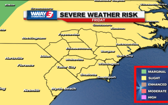
The Storm Prediction Center has the entire Cape Fear under a slight (level 2 out of 5) for severe weather Thursday night, with the same level threat carrying into the first half of Friday.
With this being an overnight event, have a way to receive alerts if tornado warnings are issued in the Cape Fear.
The StormTrack 3 weather team will be monitoring the storm and will break in on-air if the National Weather Service issues any tornado warnings.
What’s left of Nicole will pick up speed into Friday as it races towards the northeast, ushering in much colder air for Sunday and next week.