- The Texanist: Texas Gets More Tornadoes Than Any Other State, but Don’t Freak Out
- U.S. Supreme Court says Texans can sue state for flood damage
- This is how many hurricanes NC State researchers predict this year
- NC State researchers predict above-average hurricane season
- Supreme Court rules in favor of property owners suing Texas over flood damage
Houston weather: Street ponding, flooding possible overnight
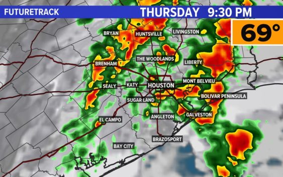
Showers and thunderstorms will continue most of Thursday night. Watch for high water spots on roadways.
HOUSTON — Rain chances will stay elevated through midnight Thursday as an upper-level disturbance combined with a surface cold front moves through the Houston area.
The heaviest rain will fall between 9 p.m. and midnight, with rain pushing east into Louisiana early Friday morning.
Localized street flooding is possible, although widespread issues are not expected.
At 8:30 p.m., the National Weather Service issued a Flood Advisory for Galveston and Brazoria counties until 10:30 p.m. The NWS said another 1.5 to 2 inches of rain was expected to fall, which could lead to localized flooding. The heavy rain was heading north, toward Huntsville.
The areas that have the highest probability of seeing heavy rain street impacts include our northern cities and counties and along the coast.
Models are showing these spots could receive an excess of 2″ of rain, which may not be manageable for poor drainage areas.
The bulk of the rain will depart the area well before sunrise Friday. However, a few showers may linger, especially at the coast during the day before nice weather arrives for the weekend.
In addition to that, look out for dense fog Friday morning from the leftover moisture.
By Friday evening it’s smooth sailing. The forecast for New Year’s celebrations continues to look good across the area. Temperatures are expected to be near 60 at midnight under mainly clear skies.
Follow the KHOU 11 Weather Team for the latest updates on the forecast: