- Families of campers, counselors who died in Texas Hill County floods sue Camp Mystic
- Small plane bound for Jamaica with hurricane relief supplies crashes in Florida neighborhood
- Ask the Meteorologist: Did a tornado hit Johnston County Saturday night?
- Demolition begins on flood-damaged homes in Stoney Creek as neighbors await relief
- NC Office of State Fire Marshal aiding in Hurricane Melissa relief efforts
Tropical update: Tropical Storm Idalia forms, latest forecast track

Idalia is expected to bring some impactful weather to the Carolinas later this week.
CHARLOTTE, N.C. —
Tropical Update
As we track a tropical system in the Gulf of Mexico this week, we’ll tweak and adjust local risks in the Charlotte area. Right now, the flood risk is highest, but depending on the eventual track, some severe weather is possible. The coast could also see a low-end surge risk. A closer proximity would result in more rain while further east would mean rain chances will be highest along the coast.
Regardless, conditions look to dry out for Labor Day weekend.
For the latest weather alerts, download the WCNC Charlotte mobile app and enable push notifications.
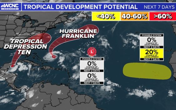
As of Sunday afternoon, there are four tropical systems to watch in the Atlantic Basin.
Tropical Storm Idalia formed near the Yucatan Channel Sunday with a path into the southern Gulf of Mexico. The system is showing signs of becoming better organized as it moves northward towards Florida and the southeast United States. The system is nearly stationary now as it moves north around 2 mph.
Interests along the United States Gulf coast, especially Florida, are watching this system closely. Model data has still been clustering on the Big Bend of Florida, as a Category 1 or 2 hurricane. There is a risk for rapid intensification.
There’s still notable uncertainty with the track of this next named storm so please stay tuned for updates from the WCNC Charlotte Weather Team. The next storm name on the 2023 list is Idalia (ee-DAL-ya).
Contact Brittany Van Voorhees at bvanvoorhe@wcnc.com and follow her on Facebook, Twitter and Instagram.