- Eric Tulsky comfortable, confident and going for the Stanley Cup in 2nd year as Hurricanes GM
- 5 homes collapse into the surf of the Outer Banks as hurricanes rumble in Atlantic
- As hurricanes pass offshore, more Buxton homes collapse into the sea
- Central Texas floods reveal need to shore up disaster response in unincorporated areas
- Latest: Tropical Storm Imelda will pull away from East Coast, expected to become a hurricane
What is a severe weather risk and how accurate is it in North Carolina?

What is a severe weather risk and how accurate is it in North Carolina?
As we continue the severe weather season in North Carolina, I wanted to update our Triangle severe weather research with updated data from the last five years. This is useful for decision making in the WRAL Severe Weather Center – but it may also be useful for you.
Severe weather can impact a lot – your yardwork, outdoor events and festivals, and day-to-day planning.
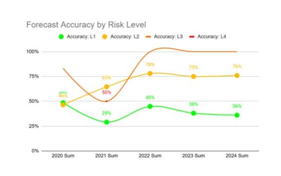
So, how are we doing with severe weather forecasting? I correlated severe weather risk levels with whether or not damage was reported that day. The bottom line here: The higher the risk, the more likely the forecast is to verify.
- Level 3 risks in the Triangle led to damage reports about 87% of the time
- Level 2 risks: 68% accuracy
- Level 1 risks: 39% accuracy
The good news is severe weather accuracy has increased slightly in recent years.
The Storm Prediction Center and WRAL News measure severe weather risks on a scale of 1 to 5, with 5 being the highest. We average about 75 days under a severe weather threat, with the most in the summer months. As we transition to summer, there is more energy available for storms (it’s hotter and more humid), but there aren’t as many fronts to help trigger organized storm systems.
Spring is the No. 1 severe weather season here in North Carolina. We average 13 tornadoes during meteorological spring in our state with several more reports of damaging winds and large hail. On average, the Triangle area sees the most higher risk days (Level 2, 3, and 4) during the spring months.

