- They couldn’t save their daughters’ lives in the July 4 floods. Now they’re dealing with the grief and the guilt.
- Austin could see heavy rains, possible flooding over the next few days
- Families of campers, counselors who died in Texas Hill County floods sue Camp Mystic
- Small plane bound for Jamaica with hurricane relief supplies crashes in Florida neighborhood
- Ask the Meteorologist: Did a tornado hit Johnston County Saturday night?
New report reveals extent of wind damage from last week's microburst in Austin

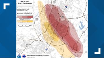
The storm covered a roughly 10-mile path that caused widespread wind damage.
AUSTIN, Texas — A preliminary assessment of the wind damage from the powerful supercell that swept through Austin on May 28 indicates widespread destruction across the metropolitan area.
While official reports are still being finalized, early findings paint a clear picture of the storm’s intensity, with wind gusts as high as 77 mph at Austin-Bergstrom International Airport – equivalent to a Category 1 hurricane.
The strongest winds are estimated to have been 85 mph, with the front flank downdraft traveling from the intersection of U.S. 183 and the MoPac Expressway to the intersection of State Highway 71 and the 130 Tollway.

The draft report highlights a range of impacts, from downed trees and power lines to significant structural damage to homes and businesses.
Austin Energy reported a peak of 72,500 customers without power at the height of the storm, making it the third-worst storm in the utility’s outage history data, surpassed only by Winter Storm Mara and Winter Storm Uri.
The primary and most pervasive impact of the high winds was the severe damage to Austin’s electrical infrastructure. Austin Energy initially identified 104 broken utility poles. Strong winds, hail and lightning damaged electrical equipment across the city, leading to numerous downed power lines. The sheer volume of downed trees and large branches played a significant role in bringing down these lines.
The sheer force of the winds resulted in notable structural damage across the city. A gas station canopy on North MoPac Expressway collapsed entirely onto a parked car, though fortunately, all occupants were able to evacuate safely. The Texas State Capitol also suffered wind-related damage, with broken glass panels observed near the top of its rotunda, highlighting the intense gusts that swept through downtown.
Austin-Bergstrom International Airport reported broken doorway glass near TSA Checkpoint 1, emphasizing the strong winds at the airport. The University of Texas at Austin’s UFCU Disch-Falk Field also saw damage to its outfield and stadium facilities, primarily from the combination of strong winds and large hail.
Residential areas, particularly in northern and eastern Austin, reported widespread damage to roofs, skylights and exterior siding. Insurance claims are expected to rise substantially as homeowners assess the full extent of the damage.
The wind tore through Austin’s urban canopy, resulting in a staggering number of downed trees and branches. The Austin Fire Department received over 100 reports of downed trees and 172 reports of arcing or downed wires, indicating the widespread nature of the wind’s impact on vegetation and related infrastructure. Many large trees were uprooted, falling across roads and fences, further complicating recovery efforts.
Early indications from the National Weather Service suggest that a long-track microburst, characterized by concentrated, powerful downdrafts, may have contributed to some of the particularly intense and focused wind damage observed in specific parts of the Austin metro area. This type of event can generate winds comparable to a weak tornado over a smaller, defined path.
The May 28 supercell was not only characterized by its damaging winds but also by large hail (some reportedly baseball-sized, up to 2.75 inches in diameter) and heavy rainfall, which led to flash flooding in areas like Shoal Creek, with some gauges recording 2-3 inches of rain in just half an hour.
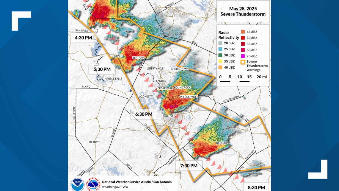
One death was also confirmed in the storm’s aftermath, highlighting the storm’s multifaceted and dangerous nature. This was part of a longer track of severe thunderstorm warnings that stretched from outside of the KVUE area in San Saba and Lampasas counties all the way through Bastrop County.


The KVUE Weather Impact Team was all over this storm every step of the way, and we will always work to keep you Weather Aware whenever severe weather hits.