- 911 calls from Texas floods reveal chaotic and desperate pleas for rescues
- Carolina Beach is warning of potential King Tide flooding
- NCDEQ launches Hurricane Helene recovery grants program
- Why no hurricanes made landfall in the US in 2025
- Florence to begin interviewing police chief finalists in January
Our stretch of hot and dry weather is coming to an end as Tropical Storm Chantal brings impacts across the Carolinas

Tropical Storm Chantal has formed and is forecasted to make landfall in South Carolina by Sunday morning
CHARLOTTE, N.C. —
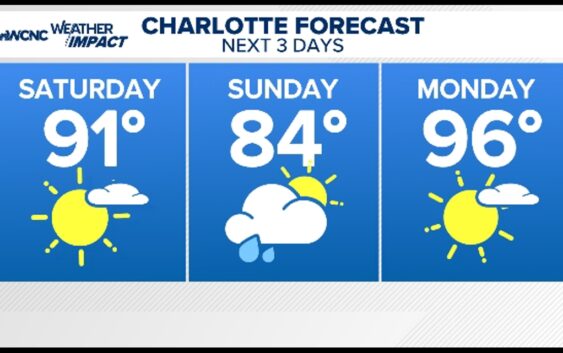
Saturday
Plan for another beautiful and hot summer day as high pressure holds strong today across the Charlotte area keeping us rain free! Highs will still reach the low-mid 90s with humidity slowing creeping in by the second half of the day. Whether you’re heading out to the golf course or out to the lake, keep in mind that winds could turn breezy at times with gusts near 25 mph.
Elsewhere near the coast, dangerous rip currents and elevated wave heights are already churning up, and expected to get worse this weekend. Heavy rain associated with a tropical system impacts the Carolina coastline beginning this afternoon.
Sunday
Sunday begins with more cloud cover and mild temperatures in the mid 70s. Watch for areas of heavy rain at times and gusty winds as the low continues to push inland, just east of the Charlotte metro.
Thankfully, this puts us on the ‘better’ side of the tropical system! Due to clouds and rainfall, highs will only reach the mid-upper 80s, even with sunshine returning in the afternoon.
Next Week
We’re watching a pattern shift early next week with drier conditions again after the low pulls away from the Carolinas. Highs will reach the mid-upper 90s for multiple days in a row.
By the end of the week, rain and storm chances slowly creep back into the forecast, allowing for highs to return to near-normal numbers. Scattered storms each afternoon and evening with highs in the low 90s.
Tropical Update
Tropical Storm Chantal formed as of 8 a.m. per the National Hurricane Center. Coastal communities will experience heavy rain at times, gusty winds, and dangerous beach conditions starting today.
While we’ll get rain with this storm as it moves even further inland Sunday, the overall impact across the Charlotte area is extremely low. Rain is already gone by Sunday afternoon and evening.
Stay connected to the WCNC Charlotte Weather Team
Contact Brad Panovich at bpanovich@wcnc.com or follow him on Facebook, X and Instagram.
Contact Bekah Birdsall at rbirdsall@wcnc.com and follow her on Facebook, X and Instagram.
Contact Chris Mulcahy at cmulcahy@wcnc.com and follow him on Facebook, X, Instagram, and TikTok.
Contact Majestic Storm at majesticstorm@wcnc.com and follow her on Facebook, X and Instagram.
Contact Brittany Van Voorhees at bvanvoorhe@wcnc.com and follow her on Facebook, X and Instagram.