- 911 calls from Texas floods reveal chaotic and desperate pleas for rescues
- Carolina Beach is warning of potential King Tide flooding
- NCDEQ launches Hurricane Helene recovery grants program
- Why no hurricanes made landfall in the US in 2025
- Florence to begin interviewing police chief finalists in January
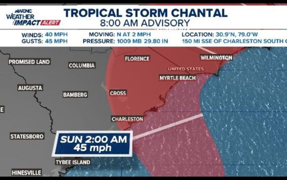
Tropical Storm Chantal has formed and now heads towards the Carolina coasts

Watch for heavy rain across the Carolina coastlines this weekend, impacting portions of the Charlotte area Sunday.
CHARLOTTE, N.C. — Tropical Storm Chantal formed Saturday at 8 a.m., per the National Hurricane Center.
It’s currently located about 150 miles south-southeast of Charleston, S.C. and is forecasted to make landfall along the South Carolina coast by Sunday morning.
Tropical Storm Watches are in place from Edisto Beach, S.C. to Little River Inlet, S.C.
Regardless of development, heavy rain is likely for South Carolina today, then pushing into North Carolina by Sunday morning. Highest rain chances will be in the eastern Carolinas, especially Raleigh area toward the coastline.
When
- Right now: Tropical Storm Chantal has formed
- Tonight through Sunday: higher rain chances along the Carolinas’ coastal areas, eventually pushing into inland communities
Impacts
- Coastal North Carolina and South Carolina could see heavy rain starting late tonight
- Rip current danger will be high throughout the weekend for both the North and South Carolina beaches
- Marine conditions will turn rough with gusty winds and wave heights up to 5-10 feet offshore
- Wind gusts along the Carolina shores could reach 35+ mph
- Locally, watch for heavy rain Sunday before quickly moving out
What you need to do and know
- Check forecasts daily, especially if you live in the Southeast, especially coastal area
- Be prepared for localized flooding or downpours, mainly near the coast and offshore.
- If you’re boating or at the beach, monitor marine warnings closely!
- Know what different beach flags mean and when it is, and isn’t, safe to swim.