- Florence to begin interviewing police chief finalists in January
- A West Texas county wants to better prepare for floods. Paying for it will be tricky.
- They couldn’t save their daughters’ lives in the July 4 floods. Now they’re dealing with the grief and the guilt.
- Austin could see heavy rains, possible flooding over the next few days
- Families of campers, counselors who died in Texas Hill County floods sue Camp Mystic
Hurricane Erin Is Growing, and So Are the Dangers It Could Bring

Hurricane Erin is growing larger, and its expected impact is starting to stretch far beyond its footprint.
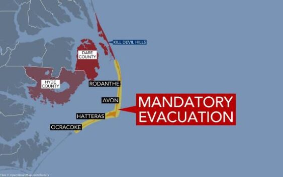
A tropical storm watch was in effect Monday for the Outer Banks of North Carolina, and officials there ordered the evacuation of some coastal areas amid concerns that bands from the storm’s outer edges could lead to heavy rain and strong winds by Wednesday. And nearly the entire east coast of the United States was at risk for dangerous rip currents, forecasters warned.
Monday, the storm’s eye was already more than 35 miles in diameter, and the tropical-storm-force winds (39 mph or higher) spinning around it stretched 230 miles from the center. Typically, a hurricane’s tropical-storm-force winds extend about 150 miles outward; Erin’s reach almost double that, and it is still growing in size, according to the National Hurricane Center.
Authorities in Hyde County, North Carolina, declared a state of emergency for Ocracoke Island on Sunday night and ordered people to leave. Officials there said that even though Erin was expected to stay well off their coast, it could still produce dangerous waves more than 20 feet high, which could possibly inundate protective dune structures along the highway.
They said that portions of Highway 12 on Ocracoke Island would likely be impassable for several days.
Monday, hundreds of tourists were leaving Ocracoke, a small coastal community that is only reachable by boat. It is packed with visitors in the summertime.
Meteorologists — and the computer models they use — remain confident that the storm will curve away from its closest point to the East Coast by the middle of the week. But any farther shifts to the west would put the North Carolina coast, especially the Outer Banks, at greater risk for tropical-stormlike conditions and possibly some hurricane-force wind gusts.
“Interests along the Outer Banks of North Carolina and Bermuda should monitor the progress of Erin, as there is a risk of strong winds associated Wednesday with the outer rain bands during the middle part of the week,” forecasters with the hurricane center wrote late Monday morning.
North Carolina juts out into the Atlantic just enough to make it prone to hurricanes or to a glancing blow as one passes by, as in the case of Erin. Over the years, the Outer Banks have endured significant damage from rising sea levels and large storm swells like those expected from Erin.
“Confidence in hazardous conditions has increased,” forecasters with the National Weather Service on the Outer Banks wrote Monday morning.
How Rip Currents Bring Danger Even Far From a Storm
A large swell is forming beneath Erin; the water’s energy will pulse toward the East Coast. When it hits the coast, that energy must go somewhere, often straight back out to sea in the form of a powerful rip current. This can happen in knee-deep water and usually in an area of the beach that looks comparatively calm, as the outgoing water can knock down incoming waves. Rip currents are the third-highest cause of death related to hurricanes.
“Life-threatening surf and rip currents will build Tuesday through Thursday,” Nelson Vas, a meteorologist with the National Weather Service in New York said Monday.
“Thursday into Friday morning looks to be the peak, with 10- to 15-feet surf likely across our ocean beaches,” he said.
Storms remaining far out at sea, such as Erin, can still affect large parts of the Eastern Seaboard, which is densely populated.
In 2008, Hurricane Bertha was more than 1,000 miles offshore, but it caused rip currents that resulted in three deaths along the New Jersey coast and led to 1,500 lifeguard rescues in Ocean City, Maryland, over a single week, according to data from the hurricane center.
A storm moving generally parallel to the East Coast can lead to rip currents from Miami up into the Northeast and Atlantic Canada. Warnings for the increased risk of rip currents have already been issued for the entire East Coast of the United States for the next few days.
When a storm is closer to shore, there’s often lightning, rain and angry seas with wind-driven sand. “Any reasonable person might conclude that it’s unsafe to be outside in these conditions,” said Jaime Rhome, deputy director of the hurricane center. But when the storm is farther away, there are fewer visual clues that something is wrong. This week, beaches could be sunny and warm with blue skies, giving no indication that it might be unsafe to enter the ocean.
“The overwhelming majority of rip current fatalities at our local beaches occur at unguarded beaches,” Vaz said.
Experts recommend swimming in areas with lifeguards and paying attention to beach warning flags for safety cues.
This article originally appeared in The New York Times.

