- 911 calls from Texas floods reveal chaotic and desperate pleas for rescues
- Carolina Beach is warning of potential King Tide flooding
- NCDEQ launches Hurricane Helene recovery grants program
- Why no hurricanes made landfall in the US in 2025
- Florence to begin interviewing police chief finalists in January
Severe weather possible Monday afternoon, hot and humid week ahead
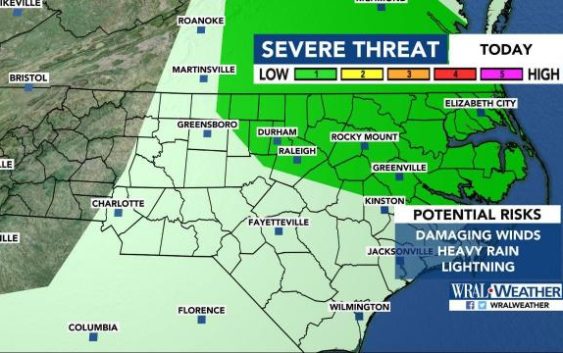
Raleigh, N.C. — Storms are likely Monday evening across central North Carolina, and the entire week will be hot and sticky.
According to WRAL meteorologist Peta Sheerwood, areas from the Triangle northeast are under a level 1 threat for severe weather on Monday, meaning damaging winds, lightning and heavy rain are possible.
In the Triangle, storms will be less severe but could interrupt outdoor plans.
According to Sheerwood, the best chance for scattered showers comes late afternoon and in the evening, “but we aren’t expecting washout conditions.”
There is a 30 percent chance for rain starting at 2 p.m. in Raleigh, and showers could pop-up during the evening commute and dinner time. By 8 p.m., rain chances decrease to 20 percent.
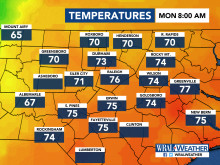
Monday will be a typical summer day, with a high around 90 degrees.
The rest of the week will be hot and sticky, with highs in the upper 80s or low 90s each day. An isolated storm can’t be ruled out any day this week, Sheerwood said, but there will be plenty of sunshine and dry weather overall.
