- Ask the Meteorologist: Did a tornado hit Johnston County Saturday night?
- Demolition begins on flood-damaged homes in Stoney Creek as neighbors await relief
- NC Office of State Fire Marshal aiding in Hurricane Melissa relief efforts
- U.S.-based aid groups rush to get supplies into storm-battered Jamaica after Hurricane Melissa
- Travelers stuck in Jamaica due to Hurricane Mellissa forced to pay for unwanted extended stay
Hurricane Michael Makes Landfall On Florida Coast
Updated: 1:55 p.m.
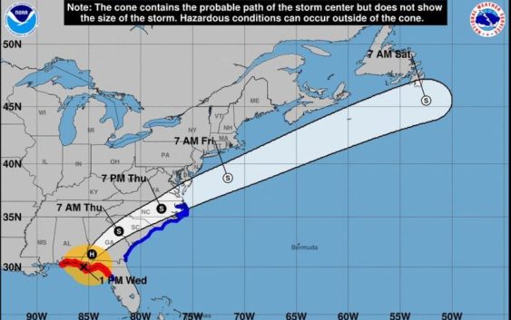
Hurricane Michael made landfall in Florida’s Mexico Beach a little after 1:40 p.m., according to the National Hurricane Center.
Michael has strengthened to a Category 4 hurricane, hitting the coast with 155 miles-per-hour winds. Hurricane-force winds extended outward up to 45 miles from the storm’s center, according to the Associated Press.
Updated: 11:50 a.m.
Gov. Roy Cooper has declared a state of emergency for North Carolina as Hurricane Michael approaches. The governor also activated 150 National Guard troops for emergency preparations and implored residents to be prepared for the coming storm.
“The last thing people cleaning up from Florence need right now is more wind and rain, but this storm is coming and we will be ready for it,” Cooper said.
Michael is expected to hit the Florida panhandle this afternoon as a Category 4 hurricane. The storm, which currently has maximum sustained winds of 145 miles per hour, is expected to weaken and track over the Carolinas Thursday, causing the first-ever tropical storm watch and warning for the area. By the time it reaches the Carolinas, it could be a tropical depression or Category 1 hurricane, according to the National Weather Service.
Michael is expected to bring heavy wind and rain to the region early tomorrow morning into tomorrow afternoon. In the latest forecast from the National Weather Service, the Charlotte metro area is expecting 4 to 6 inches of rain that could cause flooding and downed trees.
There is a flash flood watch in effect for the area.
For the first time ever, we have issued a Tropical Storm Watch & Warning for portions of our area. Flash Flood Watch in effect. It’s just a whole mess of products today, but flash flooding is our #1 concern. #scwx #gawx #ncwx #wncwx #cltwx #gspwx #avlwx https://t.co/tiHgNVUr4O pic.twitter.com/efNSPWxOVF
— NWS GSP (@NWSGSP) October 10, 2018
The National Weather Service has also issued a tropical storm watch and warning for portions for the region south of Charlotte.
The North Carolina coast, in some of the areas hit hardest by Hurricane Florence last month, is expected to get 1-2 inches of rain and see strong winds.
National Weather Service Meteorologist Jake Wimberley says the ground along the coast is already saturated and additional rainfall could cause a problem. Wimberley says he does not expect the storm to linger over North Carolina and South Carolina like Hurricane Florence did. Michael is expected to head back out into the Atlantic Ocean along the Virginia – North Carolina border.