- Small plane bound for Jamaica with hurricane relief supplies crashes in Florida neighborhood
- Ask the Meteorologist: Did a tornado hit Johnston County Saturday night?
- Demolition begins on flood-damaged homes in Stoney Creek as neighbors await relief
- NC Office of State Fire Marshal aiding in Hurricane Melissa relief efforts
- U.S.-based aid groups rush to get supplies into storm-battered Jamaica after Hurricane Melissa
What's ahead: Warmer days, chance for severe weather this week
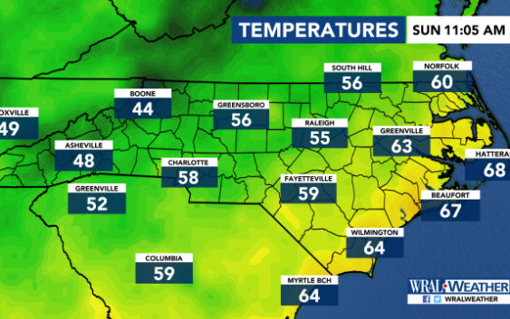
Raleigh, N.C. — Temperatures were chilly Sunday morning but are expected to warm quickly throughout the day and throughout the week.
Sunday will be beautiful and bright with plenty of sunshine and highs in the mid 60s. Some clouds are expected to move in by the afternoon, but the day should remain dry, with only a 5 percent chance of rain.
According to WRAL meteorologist Mike Moss, rain chances will increase late Sunday night and into Monday, which will have a 40 to 60 percent chance for rain for most of the day, but particularly in the morning and evening.
“It’s not going to be a washout, but we do have a number of systems that are going to bring the threat of at least scattered showers and thunderstorms to start the week,” said WRAL meteorologist Kat Campbell.
While Monday will likely see patchy showers in the Triangle, a strong cold front moving in could bring severe weather to the west and more rain to central North Carolina on Tuesday. With the storms comes an increase in temperatures — a high of 66 degrees on Monday and a high of 76 degrees on Tuesday.
The best chance for severe weather would be Tuesday, when strong winds, heavy rain and isolated tornadoes could become a concern.
By Wednesday, systems are expected to move out, leaving a calm, mild week.
