- Ask the Meteorologist: Did a tornado hit Johnston County Saturday night?
- Demolition begins on flood-damaged homes in Stoney Creek as neighbors await relief
- NC Office of State Fire Marshal aiding in Hurricane Melissa relief efforts
- U.S.-based aid groups rush to get supplies into storm-battered Jamaica after Hurricane Melissa
- Travelers stuck in Jamaica due to Hurricane Mellissa forced to pay for unwanted extended stay
Get ready for heavy rain, even flash flooding the next few days
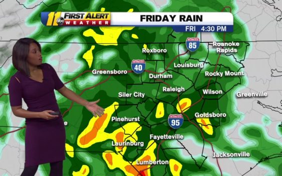
DURHAM, N.C. (WTVD) —
Get ready for a soggy Friday, and showers throughout the weekend.
An area of low pressure to the west will track across the Carolinas starting Friday. Widespread heavy rain will push into the area late Friday morning and stick around for the remainder of the day.
A few rumbles of thunder are also possible in the Sandhills. There’s also a very low risk for an isolated strong storm in Sandhills on Friday afternoon.
We’ll see rain over the next 3 days. Most of the rain will fall Friday. pic.twitter.com/tV8j9V2iQp
— Brittany Bell (@BrittanyABC11) December 14, 2018
Rain chances will be highest Friday, but this slow-moving system will still bring off and showers throughout the weekend.
Flash flooding is possible because of heavy downpours combined with melting snow. From 1-3 inches of rain could fall through Sunday. There’s a flash flood watch in effect for the entire area through Saturday.
RELATED: We’re living in the second wettest year on record in Raleigh.
High pressure will settle in early next week, drying things out.
Click here for weather alerts from the National Weather Service.
Click here for First Alert Doppler XP
Click here for the latest weather forecast.
(Copyright ©2018 WTVD-TV. All Rights Reserved.)