- Travis County is raising property taxes to pay for past and future floods
- Many ask where the hurricanes are this season as the Atlantic remains quiet
- Texas passed laws to address historic flooding. We asked a flood expert if they'll work.
- A city in Brunswick County is still repairing after Hurricane Florence
- Stein calls For $13.5 billion In new funding from Congress for Hurricane Helene Recovery
Conditions ripe for flash floods in eastern NC as rain falls all day
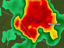
Raleigh, N.C. — The rain expected to drench the Triangle Thursday began as a light drizzle during the morning rush hour. By the time it moves out
Thursday will get a soaking throughout the day, with rain starting in the Triangle by mid-to-late morning before intensifying by lunchtime and continuing throughout the night, WRAL meteorologist Elizabeth Gardner said.
Rain started in southern North Carolina around 6 a.m. It is expected to reach the Triangle by 9 or 10 a.m. The high will be in the low 60s.
The eastern half of the state has a low threat for severe weather Thursday, but thunderstorms will likely appear by the end of the day.
The biggest threat in the weather system is wind damage, Gardner said.
The rain will taper off on Friday by early evening before clearing the way for a beautiful weekend.
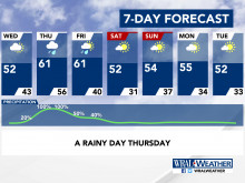
The sun returns for the weekend and warms central North Carolina into the mid-50s under mostly clear skies, ideal for any last-minute Christmas shopping. The same is in the forecast for Christmas Day: bright and sunny skies, with limited clouds and a brisk high of 52 degrees.
Christmas Eve will be similarly pleasant, with partly cloudy skies and a high around 55 degrees.
