- U.S.-based aid groups rush to get supplies into storm-battered Jamaica after Hurricane Melissa
- Travelers stuck in Jamaica due to Hurricane Mellissa forced to pay for unwanted extended stay
- Raleigh police officer awaits word from family in Jamaica after Hurricane Melissa devastation
- North Carolina’s leaders give insight on the effects of Hurricane Melissa
- ‘We want some answers;’ Whiteville residents demand city response to prevent flooding
Isolated tornado possible in central North Carolina as thunderstorms push in late Monday
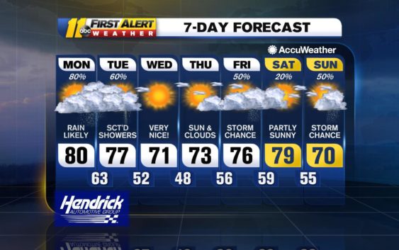
RALEIGH (WTVD) — ABC11 is in First Alert Mode as all of central North Carolina is under a severe weather risk Monday as rain, high winds, thunderstorms, and an isolated tornado are possible later in the day.
ABC11 meteorologist Steve Stewart said the storms won’t be an issue until the later afternoon/evening.
He said the chance of a thunderstorm is possible in the afternoon but will most likely occur in the evening.
The evening commute for most residents should be clear, as his prediction estimates a band of showers and heavier thunderstorms won’t push into the Triangle until 8 p.m.
He said the biggest threats with the storm are heavy winds, hail, and the chance for an isolated tornado.
Stay on top of breaking news stories with the ABC11 News App
Stewart said the chance for a tornado is low; however, it cannot be completely ruled out.
Severe risks for later today…high winds the greatest threat but an isolated tornado not out of the question as we’ll see some wind shear aloft. pic.twitter.com/22YbPYhze4
— Steve Stewart (@StewartABC11) April 8, 2019
The storm will carry on into the night, with most residents waking up to showers Tuesday morning.
Temperatures will remain in the 70s all week; rain showers chances remain high throughout the week.
Check the radar anytime with the free AccuWeather app for iPhone and Android today!
Copyright © 2019 WTVD-TV. All Rights Reserved.