- They couldn’t save their daughters’ lives in the July 4 floods. Now they’re dealing with the grief and the guilt.
- Austin could see heavy rains, possible flooding over the next few days
- Families of campers, counselors who died in Texas Hill County floods sue Camp Mystic
- Small plane bound for Jamaica with hurricane relief supplies crashes in Florida neighborhood
- Ask the Meteorologist: Did a tornado hit Johnston County Saturday night?
Timeline: Tornadoes, hail possible northeast of Houston this weekend
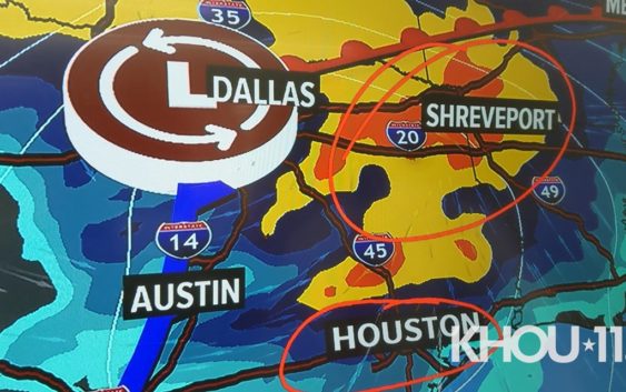
HOUSTON — We’ve enjoyed a break from the rain for much of the work week with sunny skies and only a few clouds, but KHOU 11 Meteorologist Blake Mathews says that is about to change. And some of the weather could be severe.
GET ALERTS ON THE GO: Download the KHOU 11 app
HOUSTON WEATHER TIMELINE:
Friday – Partly cloudy, 20 percent rain chance – especially in the coastal continues. Low of 62, high of 84.
Saturday – The Storm Prediction Center has placed all of southeast Texas, including Houston, in a very ‘Slight Risk’ of severe weather on Saturday. If you are traveling to the northeast of Houston, however, you’ll have a better chance of seeing severe weather. Tornadoes are possible in east and northeast Texas and into Louisiana.
Back here in the immediate Houston area, severe conditions are not expected but there is a 70 percent rain chance with a high of 80 degrees. Storms and small hail are possible, especially northeast into Livingston. There’s a rain chance in the morning with a chance for storms between noon and 4 p.m. Clearer conditions move in for the evening hours.
Sunday – The good news is we will have really nice weather on Sunday. Sunny skies and winds out of the northwest = lower humidity. High of 70 degrees. Early-morning temps in the low-50s.
Monday – Sunny conditions continue, about 10 degrees warmer than Sunday.
ALSO POPULAR TODAY ON KHOU.COM: