- 911 calls from Texas floods reveal chaotic and desperate pleas for rescues
- Carolina Beach is warning of potential King Tide flooding
- NCDEQ launches Hurricane Helene recovery grants program
- Why no hurricanes made landfall in the US in 2025
- Florence to begin interviewing police chief finalists in January
Heavy rain continues; severe weather risk increases Sunday
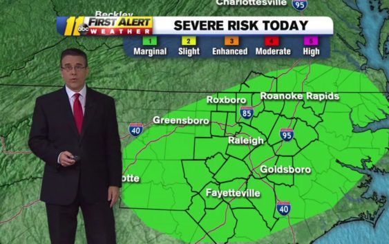
Showers and heavy downpour will continue today but the risk for severe weather, isolated tornadoes and storms increase heading into Sunday.
There is a marginal risk for severe weather on Saturday, a category 1 out of 5 for severe weather. The main risk for Saturday is straight-line winds and penny-sized hail.
RELATED: What are straight-line winds and how do they form
Severe risk increases for tomorrow with strong winds, hail and isolated tornadoes possible. Timing would be late day into the evening….possibly even overnight into Monday morning. pic.twitter.com/eXTicrW1Ke
— Steve Stewart (@StewartABC11) April 13, 2019
The ground in many areas is saturated so additional rain today will be runoff and could cause some minor areas of flash flooding.
A new area of low pressure approaches tomorrow and this one has more energy and better severe parameters so our risk for severe weather will be increasing for late in the day into the evening hours.
Sunday has a higher risk for isolated tornadoes as it is possible we could see a better chance for storms to begin rotating.
Stay on top of the latest weather updates by downloading the ABC11 app
Copyright © 2019 WTVD-TV. All Rights Reserved.