- U.S.-based aid groups rush to get supplies into storm-battered Jamaica after Hurricane Melissa
- Travelers stuck in Jamaica due to Hurricane Mellissa forced to pay for unwanted extended stay
- Raleigh police officer awaits word from family in Jamaica after Hurricane Melissa devastation
- North Carolina’s leaders give insight on the effects of Hurricane Melissa
- ‘We want some answers;’ Whiteville residents demand city response to prevent flooding
Severe storms expected across NC on Friday, tornadoes possible
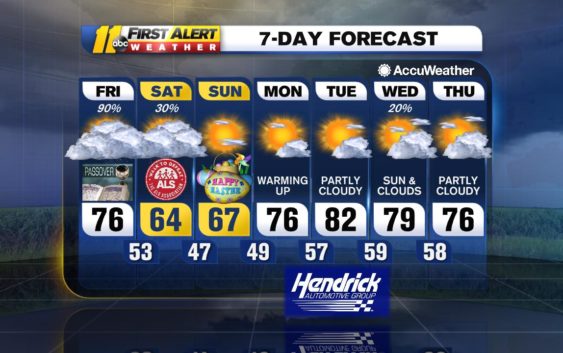
RALEIGH (WTVD) — A storm system and an associated cold front that have been responsible for severe weather across the Gulf Coast states Thursday will continue to move east Friday and into the Carolinas.
Severe weather is expected throughout the day.
There will be showers and thunderstorms in some places ahead of the main storm, and any thunderstorm can be heavy and gusty. We then we will be tracking a solid line of showers and thunderstorms that will cross the Triangle later in the afternoon and early evening.
Flooding downpours, damaging wind gusts and even an isolated tornado are all possible.
There can be a leftover shower in spots overnight and into Saturday as the upper energy with this system lags behind and slowly moves east.
Easter Sunday will see more sunshine as an upper low moves out. It will be noticeably cooler for the afternoon hours with highs in the lower 60s.
High pressure will build in Monday producing plenty of sunshine. Temperatures will recover as highs will reach the mid-70s.
A front will approach the area later Tuesday and Wednesday with some clouds. A couple of showers will be possible by Wednesday.
Check the radar anytime with the free AccuWeather app for iPhone and Android today!
Copyright © 2019 WTVD-TV. All Rights Reserved.