- 911 calls from Texas floods reveal chaotic and desperate pleas for rescues
- Carolina Beach is warning of potential King Tide flooding
- NCDEQ launches Hurricane Helene recovery grants program
- Why no hurricanes made landfall in the US in 2025
- Florence to begin interviewing police chief finalists in January
Severe weather reaches Southeastern NC
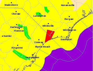
The whole region will remain under a tornado watch until midnight
Severe weather was beginning to impact the area early Friday afternoon, with all of Southeastern North Carolina under a tornado watch.
The tornado watch, which went into effect at 1:15, will remain until midnight, according to the National Weather Service’s Wilmington office (NWS).
According to a NWS forecast, a strong cold front is likely to bring “strong to severe” thunderstorms to the region throughout the afternoon and evening. The front causing the storms is likely to move off the coast around 10 p.m., per the NWS.
“Damaging wind will be the biggest threat,” the forecast stated, “but tornadoes will also be possible.”
Several flights out of Wilmington International Airport have been delayed, while three flights between ILM and Charlotte have been canceled.