- U.S.-based aid groups rush to get supplies into storm-battered Jamaica after Hurricane Melissa
- Travelers stuck in Jamaica due to Hurricane Mellissa forced to pay for unwanted extended stay
- Raleigh police officer awaits word from family in Jamaica after Hurricane Melissa devastation
- North Carolina’s leaders give insight on the effects of Hurricane Melissa
- ‘We want some answers;’ Whiteville residents demand city response to prevent flooding
Thursday's sun gives way to severe weather chance Friday
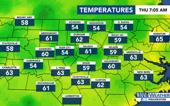
Raleigh, N.C. — It will be warm and quiet Thursday, but the Triangle’s risk for severe weather has been increased to a level 1 for Friday.
A southwesterly wind is keeping things warm Thursday, and temperatures are expected to reach 85 degrees.
Clouds will arrive throughout the day as moisture moves in, but rain isn’t expected Thursday as a high-pressure system is keeping things dry.
The U.S. Storm Prediction Center put the Triangle under a level 1 risk for severe weather on Friday, which means there’s a chance for isolated severe thunderstorms.
It will be much calmer than last Friday, when multiple tornadoes touched ground throughout the area.
Scattered showers will move in Friday morning. There’s a better chance for showers and thunderstorms in the late afternoon and early evening.

Temperatures will be in the mid-70s.
The system is expected to move out of the area by 10 p.m.
Saturday will have clear skies, and temperatures will again be in the mid-70s.
