- Small plane bound for Jamaica with hurricane relief supplies crashes in Florida neighborhood
- Ask the Meteorologist: Did a tornado hit Johnston County Saturday night?
- Demolition begins on flood-damaged homes in Stoney Creek as neighbors await relief
- NC Office of State Fire Marshal aiding in Hurricane Melissa relief efforts
- U.S.-based aid groups rush to get supplies into storm-battered Jamaica after Hurricane Melissa
Gardner: Biggest risk of strong storms is wind damage
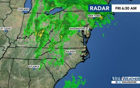
Raleigh, N.C. — A line of strong storms is moving into the Triangle on Friday, with the biggest risk being wind damage, meteorologist Elizabeth Gardner said.
The Triangle and eastward is under a level 2 risk for severe weather, which means there could be damaging winds, heavy rain and the chance for an isolated tornado.
Areas between Durham and Charlotte are under a level 1 risk.
The storm system led to reports of wind damage and a few reports of tornadoes in Louisiana and Mississippi on Thursday.
There could be a shower during the morning commute in the Triangle, with the chances for rain increasing during lunchtime.
As the front continue to move in and temperatures rise throughout the day, the risk for severe weather increases, Gardner said.
The highest chance for severe weather is around 5 p.m. just east of the Triangle, along the Interstate 95 corridor.
The area could see between a tenth and a quarter of an inch of rain.
Friday’s high will be 74 degrees.
The weekend will be clear, though, with sunny skies and warm temperatures.
Saturday will have a high in the mid-70s again, and Sunday will have a high in the low 80s.
