- New legislative panels will investigate ‘facts and circumstances’ of deadly Central Texas floods
- Heavy rain floods downtown Whiteville forcing local businesses to deal with damage again
- New legislative panels will investigate “facts and circumstances” of deadly Central Texas floods
- Springfield Middle School fully reopens next week, a year after devastating EF3 tornado
- Dozens rescued as remnants of typhoon hits Alaska while nor’easter brings flooding to East Coast
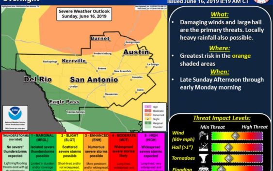
Thunderstorms capable of producing large hail, tornadoes to hit San Antonio Sunday night
-
Photo: Courtesy National Weather Service
Photo: Courtesy National Weather Service
Strong to severe thunderstorms are expected to roll into San Antonio later tonight, according to a National Weather Service forecast.
The storms will be capable of producing damaging straight-line winds of 50 to 60 miles per hour, large hail and isolated tornadoes, the NWS reported Sunday afternoon.
FIND OUT FIRST: Get San Antonio breaking news directly to your inbox
Ethan Williams, NWS meteorologist, said the storms could hit northern areas of San Antonio as early as 10 p.m. with southern portions of the city seeing storms develop from midnight to 1 a.m.
These storms may also produce up to four inches of localized rain in a short period of time with the possibility of causing minor flooding, according to the NWS.
Williams said chances for are moderate rainfall continues into Monday with a 40 percent chance of rain.
Forecasts also call for a hot and humid week for San Antonio as temperatures are expected to be in the high 90s and could reach 100 degrees by next weekend, Williams said.