- 911 calls from Texas floods reveal chaotic and desperate pleas for rescues
- Carolina Beach is warning of potential King Tide flooding
- NCDEQ launches Hurricane Helene recovery grants program
- Why no hurricanes made landfall in the US in 2025
- Florence to begin interviewing police chief finalists in January
Triangle under Level 1 risk for severe weather today
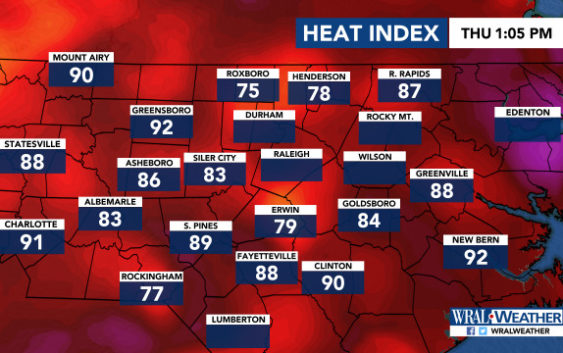
Raleigh, N.C. — The Triangle and much of central North Carolina are under a Level 1 risk for severe weather Thursday and some of the storms could be strong.
WRAL meteorologist Kat Campbell said the storms could fire up in the afternoon and last into the evening hours.
The storms could bring downpours, lightning, gusty winds and hail, she said.
But the rest of central North Carolina could also see storms with heavy rain and gusty winds.
There’s a 50 percent chance of rain in the Triangle.
Temperatures will be hot, with a high of 89 degrees in Raleigh but a heat index of 98 by the late afternoon.
Rocky Mount will feel like 102 degrees, and Fayetteville will feel like 104 degrees.
A front is bringing warm, moist air from the Gulf of Mexico, keeping the humidity at oppressive levels.
The weekend stays hot, with highs at 92 degrees and intense humidity staying put.
